IMAGES TAKEN NEAR TO
Gladstone Road, NEWARK, NG24 4HZ
Introduction
This page details the photographs taken nearby to Gladstone Road, NG24 4HZ by members of the Geograph project.
The Geograph project started in 2005 with the aim of publishing, organising and preserving representative images for every square kilometre of Great Britain, Ireland and the Isle of Man.

There are currently over 7.5m images from over14,400 individuals and you can help contribute to the project by visiting https://www.geograph.org.uk
Image Map
Images are licensed for reuse under creativecommons.org/licenses/by-sa/2.0
Notes
- Clicking on the map will re-center to the selected point.
- The higher the marker number, the further away the image location is from the centre of the postcode.
Image Listing (51 Images Found)
Images are licensed for reuse under creativecommons.org/licenses/by-sa/2.0
Image
Details
Distance
1
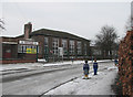
Hawtonville Junior School
These jolly bollards in the shape of primary-school children are found outside other schools in Nottinghamshire. Fortnight-old snow compacted into ice made roads and pavements perilous.
Image: © John Sutton
Taken: 10 Dec 2010
0.06 miles
2
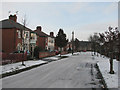
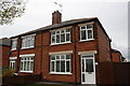
Hawtonville: Salisbury Road
Hawtonville is an early estate, dating from 1919-20. Christchurch, built in the 1950s, is at the end of the road.
Image: © John Sutton
Taken: 10 Dec 2010
0.06 miles
3
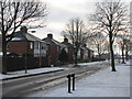
Hawtonville: Windsor Road
South Newark in the bleak mid winter - a very icy day in December, with perilous pavements. Hawtonville is a very early estate, dating from 1919-20.
Image: © John Sutton
Taken: 10 Dec 2010
0.06 miles
4
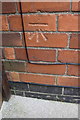
Benchmark on #42 Cleveland Square
Ordnance Survey cut mark benchmark described on the Bench Mark Database at http://www.bench-marks.org.uk/bm75305
Image: © Roger Templeman
Taken: 2 May 2016
0.07 miles
5
Nos 41 and 42 Cleveland Square
There is an OS benchmark Image on the side of the right hand house near its front corner, just through the wooden gate
Image: © Roger Templeman
Taken: 2 May 2016
0.07 miles
6
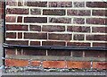
Benchmark on William Gladstone School
The Ordnance Survey cut mark benchmark which is described on the Bench Mark Database at http://www.bench-marks.org.uk/bm75459 can be seen on the brick, third from left hand edge of the image, just above the cables, with arrow cuts below the cable. There is a wider view of the location at Image
Image: © Roger Templeman
Taken: 2 May 2016
0.07 miles
7
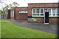
William Gladstone School, Holden Crescent
There is an OS benchmark Image on the bricks below the crocodile's nose
Image: © Roger Templeman
Taken: 2 May 2016
0.07 miles
8
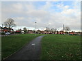
Cleveland Green
A somewhat barren open space.
Image: © Jonathan Thacker
Taken: 5 Dec 2020
0.08 miles
9

Christ Church, Newark
Designed by Broadhead and Royle 1958.
Image: © Jonathan Thacker
Taken: 5 Dec 2020
0.08 miles
10
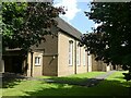
Christ Church, Hawtonville, Newark
Recreating this 'First' for the square https://www.geograph.org.uk/photo/81891 .
I had to use a slightly different viewpoint as otherwise the church would have been almost totally obscured by the trees which have made substantial growth from the saplings visible in the original view.
Image: © Alan Murray-Rust
Taken: 19 Jul 2024
0.08 miles