IMAGES TAKEN NEAR TO
Boundary Road, NEWARK, NG24 4AJ
Introduction
This page details the photographs taken nearby to Boundary Road, NG24 4AJ by members of the Geograph project.
The Geograph project started in 2005 with the aim of publishing, organising and preserving representative images for every square kilometre of Great Britain, Ireland and the Isle of Man.

There are currently over 7.5m images from over14,400 individuals and you can help contribute to the project by visiting https://www.geograph.org.uk
Image Map
Images are licensed for reuse under creativecommons.org/licenses/by-sa/2.0
Notes
- Clicking on the map will re-center to the selected point.
- The higher the marker number, the further away the image location is from the centre of the postcode.
Image Listing (62 Images Found)
Images are licensed for reuse under creativecommons.org/licenses/by-sa/2.0
Image
Details
Distance
1
Cut Mark 79 Harewood Ave Newark on Trent
Image: © Monica Stagg
Taken: 7 Sep 2015
0.03 miles
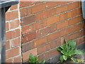
2
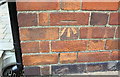
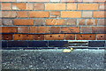
Benchmark on #79 Harewood Avenue
Ordnance Survey cut mark benchmark described on the Bench Mark Database at http://www.bench-marks.org.uk/bm70244
Image: © Roger Templeman
Taken: 2 May 2016
0.03 miles
3
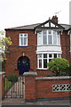
Nos. 77 and 79 Harewood Avenue
There is an OS benchmark Image on the right hand side of the right hand house
Image: © Roger Templeman
Taken: 2 May 2016
0.03 miles
4
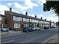
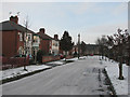
Terraced houses on Boundary Road
The style suggests they were built in the early 1900s, although they don't appear on the 1915 revision to the OS 6-inch maps.
The name of Boundary Road reflects the fact that until around 1920 it formed the boundary of the town, which was extended around that time to include the new suburb of Hawtonville, developed from 1919 onwards.
Image: © Alan Murray-Rust
Taken: 19 Jul 2024
0.04 miles
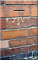
5
Benchmark on #56 Boundary Road
Ordnance Survey cut mark benchmark described on the Bench Mark Database at http://www.bench-marks.org.uk/bm70243
Image: © Roger Templeman
Taken: 2 May 2016
0.05 miles
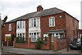
6
#56 Boundary Road
There is an OS benchmark Image on the front of the house near the left hand corner
Image: © Roger Templeman
Taken: 2 May 2016
0.05 miles
7
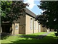
Christ Church, Hawtonville, Newark
Recreating this 'First' for the square https://www.geograph.org.uk/photo/81891 .
I had to use a slightly different viewpoint as otherwise the church would have been almost totally obscured by the trees which have made substantial growth from the saplings visible in the original view.
Image: © Alan Murray-Rust
Taken: 19 Jul 2024
0.08 miles
9
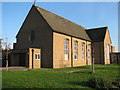
Hawtonville: Salisbury Road
Hawtonville is an early estate, dating from 1919-20. Christchurch, built in the 1950s, is at the end of the road.
Image: © John Sutton
Taken: 10 Dec 2010
0.09 miles
10
Benchmark on #40 Lime Grove
Ordnance Survey cut mark benchmark described on the Bench Mark Database at http://www.bench-marks.org.uk/bm70250
Image: © Roger Templeman
Taken: 2 Oct 2016
0.09 miles