IMAGES TAKEN NEAR TO
Marleston Lane, NEWARK, NG24 3WD
Introduction
This page details the photographs taken nearby to Marleston Lane, NG24 3WD by members of the Geograph project.
The Geograph project started in 2005 with the aim of publishing, organising and preserving representative images for every square kilometre of Great Britain, Ireland and the Isle of Man.

There are currently over 7.5m images from over14,400 individuals and you can help contribute to the project by visiting https://www.geograph.org.uk
Image Map
Images are licensed for reuse under creativecommons.org/licenses/by-sa/2.0
Notes
- Clicking on the map will re-center to the selected point.
- The higher the marker number, the further away the image location is from the centre of the postcode.
Image Listing (34 Images Found)
Images are licensed for reuse under creativecommons.org/licenses/by-sa/2.0
Image
Details
Distance
1
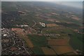
Building site on southern edge of Newark: aerial 2018
Image: © Chris
Taken: 30 Jun 2018
0.03 miles
2

Christ Church Church of England Primary School, Middlebeck
Image: © Jonathan Thacker
Taken: 18 Sep 2022
0.14 miles
3

Christ Church Primary School under construction
The new school is due to open in September 2021.
Image: © Jonathan Thacker
Taken: 1 Dec 2020
0.14 miles

5
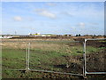
View towards Hawton Lane
Taken from Bowbridge Lane. This area is under development and will be accessed from the Neark Southern Relief Road which is under construction.
Image: © Jonathan Thacker
Taken: 3 Feb 2017
0.16 miles
6
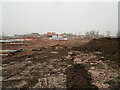
New housing development. Middlebeck
Eventually over 3,000 houses will be built in a narrow strip along the southern fringe of Newark.
Image: © Jonathan Thacker
Taken: 28 Nov 2020
0.16 miles
7
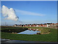
Balancing pond and new housing, Middlebeck
Image: © Jonathan Thacker
Taken: 5 Dec 2020
0.16 miles
8
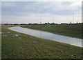
Water feature on the southern edge of Middlebeck
One of a series of balancing ponds to be excavated as part of the Middlebeck development
Image: © Jonathan Thacker
Taken: 14 Feb 2020
0.16 miles
9
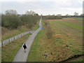
Walkies along Route 64
From the Hawton Lane bridge, looking southwards along National Cycle Route 64. The path follows the old trackbed of the Great Northern Railway line south from Newark to Bottesford, which opened in 1878 and closed in 1955.
Image: © Trevor Rickard
Taken: 22 Jan 2012
0.16 miles