IMAGES TAKEN NEAR TO
St. Peters Close, NEWARK, NG24 3SN
Introduction
This page details the photographs taken nearby to St. Peters Close, NG24 3SN by members of the Geograph project.
The Geograph project started in 2005 with the aim of publishing, organising and preserving representative images for every square kilometre of Great Britain, Ireland and the Isle of Man.

There are currently over 7.5m images from over14,400 individuals and you can help contribute to the project by visiting https://www.geograph.org.uk
Image Map
Images are licensed for reuse under creativecommons.org/licenses/by-sa/2.0
Notes
- Clicking on the map will re-center to the selected point.
- The higher the marker number, the further away the image location is from the centre of the postcode.
Image Listing (74 Images Found)
Images are licensed for reuse under creativecommons.org/licenses/by-sa/2.0
Image
Details
Distance
1
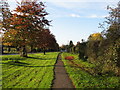
Main Street Farndon
The top of main Street before it reaches the notorious A46 junction.
Image: © Bob Danylec
Taken: 12 Nov 2005
0.05 miles
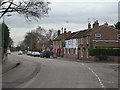
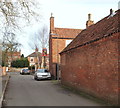
2
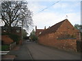
Cross Street, Farndon
The older part of Farndon is a village of substantial houses half hidden behind walls, not unlike Collingham to the north of Newark. Sadly the effect has all too often been spoiled by insensitive suburban infilling.
Image: © Jonathan Thacker
Taken: 16 Apr 2011
0.07 miles
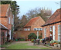
3
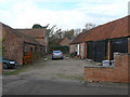
Cross Lane Farm yard
The farm outbuildings have been converted to residential use. The old farmhouse can be seen here http://www.geograph.org.uk/photo/1599790 .
Image: © Alan Murray-Rust
Taken: 27 Nov 2009
0.08 miles
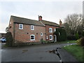
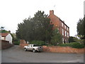
4
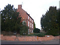
Cross Lane Farm House
Farming activity ceased some time ago. The house is an impressive 3 storey building from the late 18th century in typical Nottinghamshire style.
Image: © Alan Murray-Rust
Taken: 27 Nov 2009
0.08 miles
5
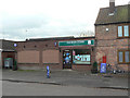
Farndon Stores
The traditional village store, recently modernised. Formerly also the Post Office, but this has moved do a different location in the village.
Image: © Alan Murray-Rust
Taken: 27 Nov 2009
0.09 miles
6
Main Street, Farndon
This linked the village to the Fosse Road and here the inn and village store can be seen.
Image: © Alan Murray-Rust
Taken: 27 Nov 2009
0.09 miles
7
Former farmhouse, West End, Farndon
Image: © Jonathan Thacker
Taken: 31 Jan 2020
0.09 miles
8
Farndon, Notts.
A courtyard and the tower of St Peter's Church seen from Cross Lane.
Image: © David Hallam-Jones
Taken: 16 Jan 2016
0.09 miles
9
Farndon, Notts.
The Rose and Crown's pub sign flags up the entrance to its car park on Cross Lane. Ahead, is a T junction with Main Street.
Image: © David Hallam-Jones
Taken: 16 Jan 2016
0.09 miles
10
West End, Farndon
The large house on the right is Cross Lane Farmhouse.
Image: © Jonathan Thacker
Taken: 16 Apr 2011
0.09 miles