IMAGES TAKEN NEAR TO
Old Mill Crescent, NEWARK, NG24 2HY
Introduction
This page details the photographs taken nearby to Old Mill Crescent, NG24 2HY by members of the Geograph project.
The Geograph project started in 2005 with the aim of publishing, organising and preserving representative images for every square kilometre of Great Britain, Ireland and the Isle of Man.

There are currently over 7.5m images from over14,400 individuals and you can help contribute to the project by visiting https://www.geograph.org.uk
Image Map
Images are licensed for reuse under creativecommons.org/licenses/by-sa/2.0
Notes
- Clicking on the map will re-center to the selected point.
- The higher the marker number, the further away the image location is from the centre of the postcode.
Image Listing (46 Images Found)
Images are licensed for reuse under creativecommons.org/licenses/by-sa/2.0
Image
Details
Distance
1
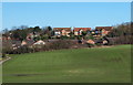
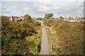
Clay Lane Vicinity, Newark-on-Trent, Notts.
A view from nearby Clay Lane railway bridge with houses in the distance on Beacon Hill. The footpath seen here links Clay Lane and Beacon Hill, crossing as it does the following residential areas: Side Row, Old Mill Crescent and Top Row.
Image: © David Hallam-Jones
Taken: 25 Feb 2016
0.06 miles
2
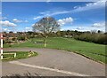
Recreation Area in Newark
Open space to the east of the town centre. Beacon hill rises in the distance.
Image: © Jonathan Clitheroe
Taken: 30 Mar 2024
0.07 miles
3
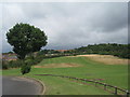
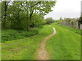
Recreation space, Beacon Hill, Newark
Image: © Jonathan Thacker
Taken: 13 Aug 2010
0.07 miles
4
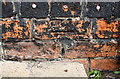
Benchmark on #78 Beacon Hill Road
Ordnance Survey cut mark benchmark described on the Bench Mark Database at http://www.bench-marks.org.uk/bm75285
Image: © Roger Templeman
Taken: 1 May 2016
0.11 miles
5
Steps up to Beacon Hill Road passing #78
There is an OS benchmark Image on the side of the house near the top of the steps
Image: © Roger Templeman
Taken: 1 May 2016
0.11 miles
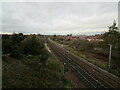
6
Footpath between housing and the East Coast railway line at Newark-on-Trent
Looking north-westward.
Image: © Peter Wood
Taken: 28 Apr 2018
0.12 miles
7
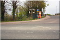
Junction of Beacon Hill Road and Cafferata Way
There used to be a pumping station at the corner
Image: © phil Richards
Taken: 1 May 2016
0.12 miles
8
The East Coast Man Line north of Clay Lane Bridge
Image: © Jonathan Thacker
Taken: 17 Nov 2020
0.13 miles
9
Route 64
View north along route 64 of the National Cycle Network from Clay Lane bridge http://www.geograph.org.uk/photo/936948
Image: © Richard Croft
Taken: 16 Oct 2008
0.13 miles
10
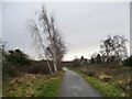
Silver birch alongside national cycle route 64
The first tree to colonise unused land. Just north of Clay Lane bridge.
Image: © Christine Johnstone
Taken: 18 Jan 2014
0.14 miles