IMAGES TAKEN NEAR TO
Bayford Drive, NEWARK, NG24 2GS
Introduction
This page details the photographs taken nearby to Bayford Drive, NG24 2GS by members of the Geograph project.
The Geograph project started in 2005 with the aim of publishing, organising and preserving representative images for every square kilometre of Great Britain, Ireland and the Isle of Man.

There are currently over 7.5m images from over14,400 individuals and you can help contribute to the project by visiting https://www.geograph.org.uk
Image Map
Images are licensed for reuse under creativecommons.org/licenses/by-sa/2.0
Notes
- Clicking on the map will re-center to the selected point.
- The higher the marker number, the further away the image location is from the centre of the postcode.
Image Listing (11 Images Found)
Images are licensed for reuse under creativecommons.org/licenses/by-sa/2.0
Image
Details
Distance
2
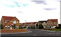
Recreation area
There is a recreation area adjacent to a new housing estate with play equipment and large areas of mown grass.
Image: © Andrew Tatlow
Taken: 31 Jul 2006
0.09 miles
3
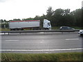
Footpath across the A1
Yes, the title is correct. I am standing at the stile on the east side of the A1. Just behind the cab of the lorry is a stile on the west side of the A1. Somehow the user of this footpath is expected to dash across two lanes of traffic moving at about 60-80 mph, climb over two crash barriers and then make another dash across another two lanes of fast moving traffic. And survive !
The footpath behind me is obstructed by crops but as this footpath is most effectively blocked by the Department of Transport I have to admit to having a certain sympathy with the farmer. At least by sowing the field with wheat he can claim to be preventing pedestrian deaths on the A1.
Image: © Jonathan Thacker
Taken: 13 Aug 2010
0.11 miles
4
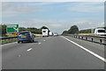
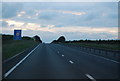
A1 northbound, half mile to Coddington turn off
Image: © J.Hannan-Briggs
Taken: 21 Aug 2013
0.11 miles
5
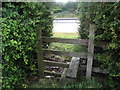
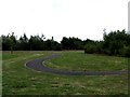
Stile on Clay Lane
See Image to see what confronts the walker beyond this stile.
Image: © Jonathan Thacker
Taken: 13 Aug 2010
0.12 miles
8
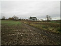
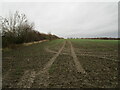
The Firs and Autumn sown field
The footpath which is the eastern extension of Clay Lane runs alongside the hedge on the right.
The Firs was once the Newark Municipal Isolation Hospital.
Image: © Jonathan Thacker
Taken: 17 Nov 2020
0.16 miles
10
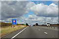
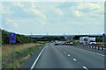
A1 approaching Coddington exit
The road through Coddington is a short cut to get on the A17 to Sleaford, but the sign bans lorries over 7.5 T from using it.
Image: © Robin Webster
Taken: 7 Oct 2011
0.20 miles