IMAGES TAKEN NEAR TO
Lombard Street, NEWARK, NG24 1XG
Introduction
This page details the photographs taken nearby to Lombard Street, NG24 1XG by members of the Geograph project.
The Geograph project started in 2005 with the aim of publishing, organising and preserving representative images for every square kilometre of Great Britain, Ireland and the Isle of Man.

There are currently over 7.5m images from over14,400 individuals and you can help contribute to the project by visiting https://www.geograph.org.uk
Image Map
Images are licensed for reuse under creativecommons.org/licenses/by-sa/2.0
Notes
- Clicking on the map will re-center to the selected point.
- The higher the marker number, the further away the image location is from the centre of the postcode.
Image Listing (1380 Images Found)
Images are licensed for reuse under creativecommons.org/licenses/by-sa/2.0
Image
Details
Distance
1
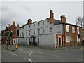
Potterdyke House, Newark
Dates from the mid seventeenth century though much altered and extended https://historicengland.org.uk/listing/the-list/list-entry/1297716?section=official-list-entry
Image: © Jonathan Thacker
Taken: 13 Mar 2022
0.01 miles
2
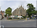
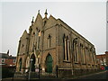
Former Christ Church
Anglican church of 1836, architect J D Paine, which became redundant towards the latter part of the 20th century and was converted around 1987 to a furniture warehouse. Listed Grade II.
Image: © Alan Murray-Rust
Taken: 31 Aug 2012
0.01 miles
3
Lombard Street, Newark, Notts.
A former church, opposite the entrance to the town's bus station, is now being used as an antique centre.
Image: © David Hallam-Jones
Taken: 21 Nov 2015
0.01 miles
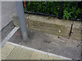
4
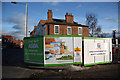
Asda Newark is coming soon
Lombard Street and construction site hoarding where the entrance to the bus station used to be
Image: © Richard Croft
Taken: 7 Feb 2011
0.02 miles
5
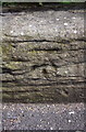
Benchmark on Lombard Street wall
Ordnance Survey cut mark benchmark described on the bench Mark Database at http://www.bench-marks.org.uk/bm45346
Image: © Roger Templeman
Taken: 2 May 2016
0.02 miles
6
Bench mark, Christ Church, Newark
A seriously eroded mark which took me two visits to locate. On the west corner of the wall surrounding the former Christ Church on Lombard Street. http://www.geograph.org.uk/photo/3118087
Image: © Alan Murray-Rust
Taken: 4 Sep 2012
0.02 miles
7
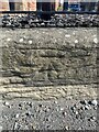
Cut mark: Newark on Trent, Lombard St, Kingsman Interiors
This worn cut mark is on the wall outside the former Christ Church, Lombard St, near the pedestrian crossing
Image: © michael lawrence
Taken: 12 Aug 2023
0.02 miles
8
St. Mark's Lane, Newark
Redeveloped in the late 1970s and providing a pedestrian route from Lombard Street to the Market Place.
Image: © Jonathan Thacker
Taken: 30 Dec 2020
0.02 miles
9
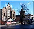
Former Christ Church, Newark
Built 1836-7 and designed by W.A.Nicholson https://en.wikipedia.org/wiki/William_Adams_Nicholson It is not oriented. The church closed in 1957 being replaced by a new building in the suburbs Image It is now a furniture store. https://historicengland.org.uk/listing/the-list/list-entry/1196270
Image: © Jonathan Thacker
Taken: 30 Dec 2020
0.03 miles
10
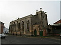
Former Christ Church, Newark from the north east
The apse appears almost as a low tower. Built 1836-7 and designed by W.A.Nicholson https://en.wikipedia.org/wiki/William_Adams_Nicholson It is not oriented. The church closed in 1957 being replaced by a new building in the suburbs Image It is now a furniture store. https://historicengland.org.uk/listing/the-list/list-entry/1196270
Image: © Jonathan Thacker
Taken: 30 Dec 2020
0.03 miles