IMAGES TAKEN NEAR TO
Sleaford Road, NEWARK, NG24 1NF
Introduction
This page details the photographs taken nearby to Sleaford Road, NG24 1NF by members of the Geograph project.
The Geograph project started in 2005 with the aim of publishing, organising and preserving representative images for every square kilometre of Great Britain, Ireland and the Isle of Man.

There are currently over 7.5m images from over14,400 individuals and you can help contribute to the project by visiting https://www.geograph.org.uk
Image Map
Images are licensed for reuse under creativecommons.org/licenses/by-sa/2.0
Notes
- Clicking on the map will re-center to the selected point.
- The higher the marker number, the further away the image location is from the centre of the postcode.
Image Listing (158 Images Found)
Images are licensed for reuse under creativecommons.org/licenses/by-sa/2.0
Image
Details
Distance
1
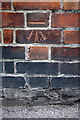
Benchmark on wall at side of #42 Wellington Road
Ordnance Survey cut mark benchmark described on the Bench Mark Database at http://www.bench-marks.org.uk/bm24255
Image: © Roger Templeman
Taken: 1 May 2016
0.02 miles
2
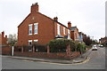
Houses of Wellington Road at Sleaford Road junction
There is an OS benchmark Image on the brick wall near the gate which gives access to the rear of #42 Wellington Road
Image: © Roger Templeman
Taken: 1 May 2016
0.03 miles
3
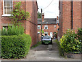
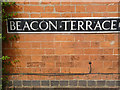
Beacon Terrace
The alley leads to the terrace of houses with this name, set back behind Friary Road without any other road access. The bench mark illustrated here http://www.geograph.org.uk/photo/3116551 is on the gable wall on the left, hidden by the hedge.
Image: © Alan Murray-Rust
Taken: 31 Aug 2012
0.08 miles
4
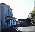
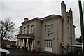
Beacon Hill Road, Newark on Trent, Notts.
This Grade II-listed building was home to Hatton House (Boys’) Boarding School c.1885. It was named after the Finch-Hatton family, Earls of Winchilsea & Nottingham. The 1892 Newark trade directory lists the Rev. Thomas Cranmer as its Headmaster. Its most recent users were members of Newark Working Men's Club. Currently it is empty and it is being revamped for an alternative user.
Image: © David Hallam-Jones
Taken: 5 Nov 2017
0.09 miles
5
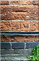
Bench mark, 5 Friary Road
A rather worn cut mark. Not easy to spot, it's directly below the 'C' of Beacon, just above the telephone cables. See http://www.geograph.org.uk/photo/3116553 for location.
Image: © Alan Murray-Rust
Taken: 31 Aug 2012
0.09 miles
6
Benchmark on #5 Friary Road
Ordnance Survey cut mark benchmark described on the Bench Mark Database at http://www.bench-marks.org.uk/bm24253
Image: © Roger Templeman
Taken: 1 May 2016
0.09 miles
7
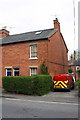
#5 Friary Road at Beacon Terrace junction
There is an OS benchmark Image on the right hand side of the house near its front corner
Image: © Roger Templeman
Taken: 1 May 2016
0.09 miles
9
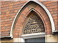
The Old Willow Pattern, detail
An idiosyncratic name for a fairly standard Victorian villa http://www.geograph.org.uk/photo/3116554
Image: © Alan Murray-Rust
Taken: 31 Aug 2012
0.10 miles
10
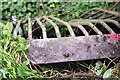
Grill on culvert for stream under Sleaford Road
Image: © phil Richards
Taken: 1 May 2016
0.10 miles