IMAGES TAKEN NEAR TO
Appleton Gate, NEWARK, NG24 1LF
Introduction
This page details the photographs taken nearby to Appleton Gate, NG24 1LF by members of the Geograph project.
The Geograph project started in 2005 with the aim of publishing, organising and preserving representative images for every square kilometre of Great Britain, Ireland and the Isle of Man.

There are currently over 7.5m images from over14,400 individuals and you can help contribute to the project by visiting https://www.geograph.org.uk
Image Map
Images are licensed for reuse under creativecommons.org/licenses/by-sa/2.0
Notes
- Clicking on the map will re-center to the selected point.
- The higher the marker number, the further away the image location is from the centre of the postcode.
Image Listing (373 Images Found)
Images are licensed for reuse under creativecommons.org/licenses/by-sa/2.0
Image
Details
Distance
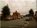
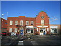
3
Kwik Fit in Sleaford Road, Newark-on-Trent
The building was originally a bus garage.
Image: © Chris
Taken: 2 Mar 2014
0.02 miles
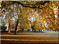
4
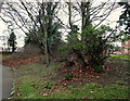
Friary Park, Sleaford Road, Newark, Notts.
With Sleaford Road beyond the stone wall on the photographer's right, and looking in the direction of Queen's road (towards the town centre), these are remains of ramparts and ditches that formed part the north-eastern corner of Newark's Civil War town defences (1642-46). Where the ground slopes upwards to meet the wall it has been suggested that the height of these earthwork defences could have measured between 8-12 metres.
Image: © David Hallam-Jones
Taken: 1 Feb 2015
0.03 miles
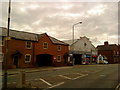
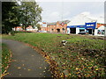
5
Newark Bathrooms
Former utility offices.
Image: © Jonathan Thacker
Taken: 22 Jan 2021
0.03 miles
6
Line of Civil War defences, Friary Gardens, Newark
The defences were constructed between 1642 and 1646 and overlay the precinct wall of the Newark Friary https://historicengland.org.uk/listing/the-list/list-entry/1016020
Image: © Jonathan Thacker
Taken: 26 Oct 2021
0.03 miles
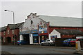
7
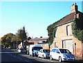
Appleton Gate, Newark on Trent, Notts.
A boarded up house on Appleton Gate, en route to the town centre. It may be in use by an adjoining builder's merchant's yard as a storage facility?
Image: © David Hallam-Jones
Taken: 5 Nov 2017
0.04 miles
9
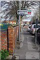
Appleton Gate, Newark on Trent
The name of this road indicates that apples were once grown here. Nowadays, it links Newark town centre with Northgate station - the more important of the two in the town.
Image: © Stephen McKay
Taken: 24 Mar 2023
0.04 miles
10

Police Station, Queen's Street, Newark, Notts.
The town's new-ish Police Station is seen here from the junction with Appleton Gate.
Image: © David Hallam-Jones
Taken: 1 Feb 2015
0.04 miles