IMAGES TAKEN NEAR TO
Mount Close, NEWARK, NG24 1JQ
Introduction
This page details the photographs taken nearby to Mount Close, NG24 1JQ by members of the Geograph project.
The Geograph project started in 2005 with the aim of publishing, organising and preserving representative images for every square kilometre of Great Britain, Ireland and the Isle of Man.

There are currently over 7.5m images from over14,400 individuals and you can help contribute to the project by visiting https://www.geograph.org.uk
Image Map
Images are licensed for reuse under creativecommons.org/licenses/by-sa/2.0
Notes
- Clicking on the map will re-center to the selected point.
- The higher the marker number, the further away the image location is from the centre of the postcode.
Image Listing (1046 Images Found)
Images are licensed for reuse under creativecommons.org/licenses/by-sa/2.0
Image
Details
Distance
1
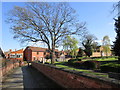
Mount Lane, Newark
On the right is the closed churchyard which has been laid out as gardens.
Image: © Jonathan Thacker
Taken: 11 Apr 2019
0.01 miles
2
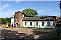
Mount School buildings
The tower carries the date 1877, but the schoolroom itself dates from 1826 (architect W M Fowler), and the cross wing to the left of the tower from 1838. Listed Grade II. Redevelopment of the school site has opened up this view of the buildings, although to judge by the foundations in the foreground, regrettably not for much longer. The buildings have been refurbished as part of the redevelopment.
Image: © Alan Murray-Rust
Taken: 4 Sep 2012
0.02 miles
3
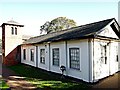
Appleton Gate Vicinity, Newark on Trent, Notts.
This view is from Mount Close - a wide path linking Appleton Gate and King's Road - through some railings surrounding what is now the Parson's Mount sheltered accommodation complex (built in phases between 2014-2017). This is Grade II-listed Old Schoolroom at the south east end of the former Mount School Primary School site. The original school building - beyond the bell tower and behind the extension in the forefront - was opened in 1826. It was designed by W. M. Fowler. The extension dates from 1838 and the bell tower from 1877. The Old Schoolroom now houses residential accommodation, and possibly administrative offices, associated with the Parson's Mount complex. Immediately behind the photographer lies the Parish Church graveyard.
Image: © David Hallam-Jones
Taken: 29 Oct 2017
0.02 miles
4
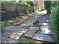
Graveyard for gravestones
Headstones taken from the churchyard of St. Mary Magdalene's church and laid to rest.
Image: © Jonathan Thacker
Taken: 5 Aug 2011
0.02 miles
5
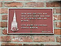
Civil War Plaque in Mount Lane
Helps pick out where a cannon=ball crashed into the church spire of St Mary Magdalene visible above to the right.
Image: © El Loco
Taken: 23 May 2021
0.02 miles
6
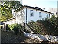
Appleton Gate Vicinity, Newark on Trent, Notts.
The C19th Grade II-listed Old Schoolroom at the south east end of the former Mount School Primary School site. This, the original school building was opened in 1826. It was designed by W. M. Fowler. The extension behind the house dates from 1838 and the bell tower (just visible) from 1877. Part of the new Parson's Mount sheltered housing complex, built in phases between 2014-2017, is visible behind. The Old Schoolroom now houses residential accommodation, and perhaps, administrative offices associated with the Parson's Mount complex. Immediately ahead , though not visible, is part of the boundary wall of the Parish Church's graveyard and Mounts Close, a footpath linking Appleton Gate and King's Road.
Image: © David Hallam-Jones
Taken: 29 Oct 2017
0.02 miles
7
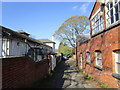
Mount Close, Newark
The former premises of the Mount School on the left https://historicengland.org.uk/listing/the-list/list-entry/1196383
Image: © Jonathan Thacker
Taken: 11 Apr 2019
0.02 miles
8
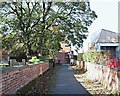
King's Road Vicinity, Newark on Trent, Notts.
This footpath - Mounts Close - links Appleton Gate (150 metres behind the photographer) with King's Road, ahead. On the left is the boundary wall of the Parish Church graveyard, whilst on the right is the Parson's Mount sheltered housing complex, that was built in phases between 2014-2017 on a site that originally hosted the Parish Church's parsonage, and later, the former Mount School.
Image: © David Hallam-Jones
Taken: 29 Oct 2017
0.02 miles
9
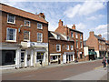
23 to 37 Appletongate
A variety of houses from the late 18th and early 19th centuries, most with relatively unchanged 19th century shop fronts inserted later. Except for the obviously modern shop with the green awning, all are Listed Grade II.
Image: © Alan Murray-Rust
Taken: 31 Aug 2012
0.02 miles
10
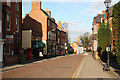
Appletongate
View north along Appletongate from The Palace Theatre
Image: © Richard Croft
Taken: 7 Feb 2011
0.02 miles