IMAGES TAKEN NEAR TO
NG2 3HY
Introduction
This page details the photographs taken nearby to NG2 3HY by members of the Geograph project.
The Geograph project started in 2005 with the aim of publishing, organising and preserving representative images for every square kilometre of Great Britain, Ireland and the Isle of Man.

There are currently over 7.5m images from over14,400 individuals and you can help contribute to the project by visiting https://www.geograph.org.uk
Image Map
Images are licensed for reuse under creativecommons.org/licenses/by-sa/2.0
Notes
- Clicking on the map will re-center to the selected point.
- The higher the marker number, the further away the image location is from the centre of the postcode.
Image Listing (321 Images Found)
Images are licensed for reuse under creativecommons.org/licenses/by-sa/2.0
Image
Details
Distance
1
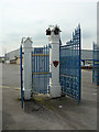
Cattle market gates
The Cattle Market Road entrance to the former market site. The fine cast iron gateposts with their bulls' heads and the wrought iron gates have been retained and refurbished.
Image: © Alan Murray-Rust
Taken: 29 May 2008
0.01 miles
2
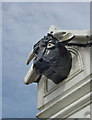
Sad looking bull
One of the bulls' heads on the Cattle Market Road gates. This is a modern replacement - several of the original heads had been broken over the years.
Image: © Alan Murray-Rust
Taken: 29 May 2008
0.01 miles
3
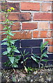
Part of benchmark on the Slaughter House
Ordnance Survey cut mark benchmark described on the Bench Mark Database at http://www.bench-marks.org.uk/bm35584
Image: © Roger Templeman
Taken: 1 Jun 2018
0.02 miles
4
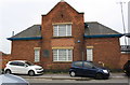
Building of former slaughterhouse
There is an OS benchmark Image on the front right of the building at the junction with the brick wall
Image: © Roger Templeman
Taken: 1 Jun 2018
0.02 miles
5
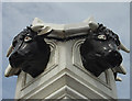
Looking both ways
Bulls' heads on the former cattle market entrance gates. Careful study shows that the two heads are not quite identical, even allowing for the fact that the right hand one has lost an ear. This one is an original casting, and shows a slightly rougher finish than the modern replacement on the left. There are also slight differences in the angle of the horns. It is nevertheless gratifying that the effort was made to refurbish the gates to this extent.
Image: © Alan Murray-Rust
Taken: 29 May 2008
0.02 miles
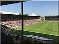
6
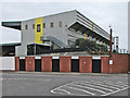
The Spion Kop End at Meadow Lane
In the old days, like kop ends at other grounds, Notts County's Spion Kop End was a steep open terrace. (The name of these terraces derives from a battle in the Boer War, fought on a steep hill near Ladysmith.)
Image: © John Sutton
Taken: 14 Aug 2016
0.04 miles
7
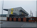
Meadow Lane football ground, County Road
Image: © Bryn Holmes
Taken: 3 Mar 2018
0.04 miles
8
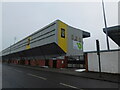
Meadow Lane football ground, County Road
Image: © Bryn Holmes
Taken: 3 Mar 2018
0.04 miles
10
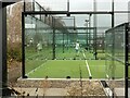
Nottingham Padel Centre
Inaugurated at the end of 2022 by Notts County Football Club. There are 4 courts. The glass panels make for some interesting reflections.
Image: © Alan Murray-Rust
Taken: 1 Mar 2023
0.06 miles