IMAGES TAKEN NEAR TO
London Road, NOTTINGHAM, NG2 3BA
Introduction
This page details the photographs taken nearby to London Road, NG2 3BA by members of the Geograph project.
The Geograph project started in 2005 with the aim of publishing, organising and preserving representative images for every square kilometre of Great Britain, Ireland and the Isle of Man.

There are currently over 7.5m images from over14,400 individuals and you can help contribute to the project by visiting https://www.geograph.org.uk
Image Map
Images are licensed for reuse under creativecommons.org/licenses/by-sa/2.0
Notes
- Clicking on the map will re-center to the selected point.
- The higher the marker number, the further away the image location is from the centre of the postcode.
Image Listing (326 Images Found)
Images are licensed for reuse under creativecommons.org/licenses/by-sa/2.0
Image
Details
Distance
1
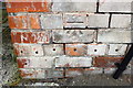
Benchmark on Nottingham City Council Eastcroft depot building
Ordnance Survey cut mark benchmark levelled at 24.732m above Newlyn Datum
Image: © Roger Templeman
Taken: 1 Jun 2018
0.03 miles
2
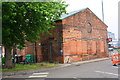
Building at Nottingham City Council Eastcroft Depot, Incinerator Road
There is an OS benchmark Imageon the near corner, right hand face of the building
Image: © Roger Templeman
Taken: 1 Jun 2018
0.03 miles
3
Looking into waste processing depot from security gate
Image: © Luke Shaw
Taken: 28 Jan 2022
0.05 miles
4
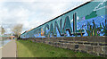
Mural alongside The Nottingham Canal, Nottingham
Image: © habiloid
Taken: 17 Feb 2023
0.06 miles
5
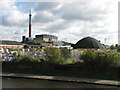
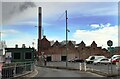
View from London Road
The Nottingham Canal and towpath are in the foreground and the Nottingham incinerator and its tall chimney in the background. I don't know what the umbrella-shaped building is. There's a glimpse of the steep cliff of Colwick Woods in the distance to the right of the incinerator.
Image: © John Sutton
Taken: 24 Aug 2010
0.06 miles
6
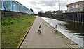
Canada Geese, The Nottingham Canal, Nottingham
Image: © habiloid
Taken: 17 Feb 2023
0.06 miles
7
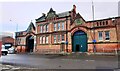
Former 'The Nottingham Hide Skin & Fat Market Company Limited' building
Ordnance Survey records indicate that a benchmark levelled at 26.240m above Newlyn Datum was verified in 1962 on the front of the building at its left hand corner
Image: © Roger Templeman
Taken: 28 Jan 2022
0.06 miles
8
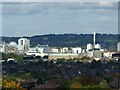
Nottingham in the sun ? 1
Telephoto view from Wilford Hill. Prominent are the chimney of the refuse incinerator (right) and (left) the telephone exchange tower.
Image: © Alan Murray-Rust
Taken: 10 Oct 2021
0.07 miles
9
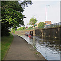
Nottingham Canal: towards the Trent
Just before eight o'clock on a summer morning a narrowboat was making its way from overnight moorings towards Meadow Lane Lock and the River Trent. In the background, on the other side of London Road, is Nottingham's new fire station.
Image: © John Sutton
Taken: 21 Jun 2017
0.07 miles
10
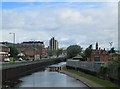
London Road and the Nottingham Canal
A Saturday-morning view from Cattle Market Road bridge.
Image: © John Sutton
Taken: 15 Jun 2013
0.07 miles