IMAGES TAKEN NEAR TO
Dykes End, NEWARK, NG23 7LD
Introduction
This page details the photographs taken nearby to Dykes End, NG23 7LD by members of the Geograph project.
The Geograph project started in 2005 with the aim of publishing, organising and preserving representative images for every square kilometre of Great Britain, Ireland and the Isle of Man.

There are currently over 7.5m images from over14,400 individuals and you can help contribute to the project by visiting https://www.geograph.org.uk
Image Map
Images are licensed for reuse under creativecommons.org/licenses/by-sa/2.0
Notes
- Clicking on the map will re-center to the selected point.
- The higher the marker number, the further away the image location is from the centre of the postcode.
Image Listing (92 Images Found)
Images are licensed for reuse under creativecommons.org/licenses/by-sa/2.0
Image
Details
Distance
1
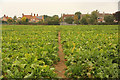
Footpath to Dykes End
Public footpath approaching Collingham
Image: © Richard Croft
Taken: 20 Sep 2014
0.07 miles
2
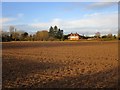
Prepared field on the edge of Collingham
Image: © Jonathan Thacker
Taken: 15 Dec 2019
0.08 miles
3
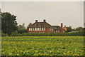
South Collingham Hall
South Collingham Hall, now a care home
Image: © Richard Croft
Taken: 20 Sep 2014
0.08 miles
4
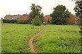
Footpath to The Paddock
Public footpath between Station Road and The Paddock at Dykes End
Image: © Richard Croft
Taken: 20 Sep 2014
0.08 miles
5
Collingham High Street
A newly built house on the site of the former garage and the Kings Head pub on Collingham High Street
Image: © Richard Croft
Taken: 14 Aug 2008
0.11 miles
6
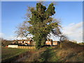
Footpath to Dykes End, Collingham
Passes an ash tree almost totally covered in ivy.
Image: © Jonathan Thacker
Taken: 15 Dec 2019
0.11 miles
7
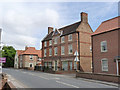
The Red House
A large mid-18th century house, later converted to include 3 shops.
Compare with http://www.geograph.org.uk/photo/937415 - the window surrounds have been painted in a more traditional colour, and the front door has been rebuilt to nearer its original pattern. Interestingly, the local Conservation Area appraisal has encouraged the retention of redundant shop fronts to emphasise the historic importance of retail trades in this thriving village, so it will be interesting to see whether further changes occur. Listed grade II.
Image: © Alan Murray-Rust
Taken: 5 Aug 2012
0.12 miles
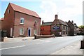
8
The King's Head
Traditional pub serving the south part of the village.
Image: © Alan Murray-Rust
Taken: 5 Aug 2012
0.12 miles
9
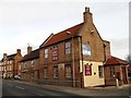
The Kings Head
The pub closed its doors in 2015 but may be re-opening soon as a pub and restaurant.
Image: © Graham Hogg
Taken: 29 Feb 2016
0.12 miles
10
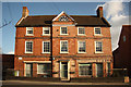
The Red House
Grade II listed, mid-18th century house on High Street
Image: © Richard Croft
Taken: 4 Feb 2013
0.13 miles