IMAGES TAKEN NEAR TO
NG23 6SJ
Introduction
This page details the photographs taken nearby to NG23 6SJ by members of the Geograph project.
The Geograph project started in 2005 with the aim of publishing, organising and preserving representative images for every square kilometre of Great Britain, Ireland and the Isle of Man.

There are currently over 7.5m images from over14,400 individuals and you can help contribute to the project by visiting https://www.geograph.org.uk
Image Map
Images are licensed for reuse under creativecommons.org/licenses/by-sa/2.0
Notes
- Clicking on the map will re-center to the selected point.
- The higher the marker number, the further away the image location is from the centre of the postcode.
Image Listing (47 Images Found)
Images are licensed for reuse under creativecommons.org/licenses/by-sa/2.0
Image
Details
Distance
1
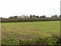
Farm buildings near High Marnham
There doesn't appear to ever have been a farmhouse here and the location is unnamed on OS mapping.
Taking from the intriguingly named Polly Taylor's Road. Who was she?
Image: © Alan Murray-Rust
Taken: 28 Sep 2017
0.04 miles
2
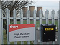
Former Entrance to High Marnham PS
Former entrance with postbox! Cooling towers in background
Image: © Paul Allison
Taken: 2 Feb 2008
0.12 miles
3

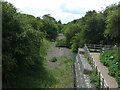
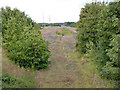
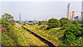
Railway track bed
Once a double track railway which led into the now closed High Marnham power station the railway has been lifted here back to the former junction with the Tuxford to Lincoln line around the corner.
Image: © roger geach
Taken: 15 Nov 2009
0.12 miles
4
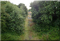
Disused railway line into High Marnham Power Station
Looking west from the road bridge.
Image: © Alan Murray-Rust
Taken: 22 Aug 2014
0.14 miles
5
High Marnham Power Station sidings
Seen from the road bridge at Fledborough Station.
Image: © Alan Murray-Rust
Taken: 22 Aug 2014
0.18 miles
6
View east towards High Marnham Substation
At the site of the former High Marnham Power Station which was demolished on 15 July 2012.
Image: © Mat Fascione
Taken: 7 May 2016
0.18 miles
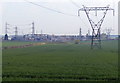
8
Pylons to the Power Station
The now closed High Marnham power station in the distance still has many power lines coming from it.
Image: © Michael Patterson
Taken: 8 May 2006
0.19 miles
9
Fledborough station (remains), 1995
View eastward, towards Lincoln (over River Trent ahead): ex-GCR (Lancashire, Derbyshire & East Coast) Chesterfield - Shirebrook - Lincoln line. The station closed to passengers when the service Shirebrook - Lincoln ended 19/9/55, but to goods not until 4/1/65. Over on the right is High Marnham Power Station, closed 2003, which was served off this railway from Shirebrook to a junction just west of here. (Cf. Image]).
Image: © Ben Brooksbank
Taken: 2 May 1995
0.19 miles