IMAGES TAKEN NEAR TO
Ferry Lane, NEWARK, NG23 6NS
Introduction
This page details the photographs taken nearby to Ferry Lane, NG23 6NS by members of the Geograph project.
The Geograph project started in 2005 with the aim of publishing, organising and preserving representative images for every square kilometre of Great Britain, Ireland and the Isle of Man.

There are currently over 7.5m images from over14,400 individuals and you can help contribute to the project by visiting https://www.geograph.org.uk
Image Map
Images are licensed for reuse under creativecommons.org/licenses/by-sa/2.0
Notes
- Clicking on the map will re-center to the selected point.
- The higher the marker number, the further away the image location is from the centre of the postcode.
Image Listing (119 Images Found)
Images are licensed for reuse under creativecommons.org/licenses/by-sa/2.0
Image
Details
Distance
1
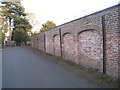
Leaning Wall
This wall is propped up with steel girders. The section to the right, just out of sight, has collapsed.
Image: © Jonathan Thacker
Taken: 7 Oct 2011
0.04 miles
3
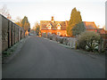
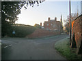
Ferry Lane
Looking westwards from the junction with Church Lane as early morning sunlight catches Holly Farm on the right. The walled garden of Carlton Hall is on the left, which has a plant nursery in the stable yard.
Image: © Trevor Rickard
Taken: 16 Jan 2012
0.05 miles
4
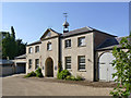
Stable block, Carlton Hall
Early 19th century, with projecting central bay and pediment. Now converted for use by small businesses. Listed Grade II.
Image: © Alan Murray-Rust
Taken: 24 Jul 2014
0.05 miles
5
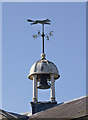
Bellcote and weathervane, Carlton Hall stables
The fox on the weather vane indicates the main reason for required stabling for large numbers of horses.
Image: © Alan Murray-Rust
Taken: 24 Jul 2014
0.05 miles
6
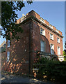
The Dower House
Looking south down Church Lane towards the spire of St Mary's in the background. On the left is Ferry Lane. The 18th/19th century house and its garden wall are both Grade II Listed.
Image: © Trevor Rickard
Taken: 16 Jan 2012
0.06 miles
7
The Dower House, Carlton
Basically a 19th century house, but incorporating an earlier, 18th century, building. The name indicates that it was built to accommodate the former lady of the main house - Carlton Hall - after the death of her husband. Listed Grade II.
Image: © Alan Murray-Rust
Taken: 24 Jul 2014
0.07 miles
8

Ferry Farmhouse, Carlton-on-Trent
Built in 1737 it is a large example of its type, stretching to 7 bays. Listed Grade II.
Image: © Alan Murray-Rust
Taken: 24 Jul 2014
0.07 miles
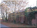
9
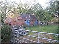
Old stables, Carlton on Trent
Gently falling into dereliction.
Image: © Jonathan Thacker
Taken: 7 Oct 2011
0.08 miles
10
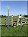
Trentside stile
The footpath doesn't actually run alongside the river but simply loops back into the village.
Image: © Alan Murray-Rust
Taken: 24 Jul 2014
0.09 miles