IMAGES TAKEN NEAR TO
The Vines, NEWARK, NG23 6NH
Introduction
This page details the photographs taken nearby to The Vines, NG23 6NH by members of the Geograph project.
The Geograph project started in 2005 with the aim of publishing, organising and preserving representative images for every square kilometre of Great Britain, Ireland and the Isle of Man.

There are currently over 7.5m images from over14,400 individuals and you can help contribute to the project by visiting https://www.geograph.org.uk
Image Map
Images are licensed for reuse under creativecommons.org/licenses/by-sa/2.0
Notes
- Clicking on the map will re-center to the selected point.
- The higher the marker number, the further away the image location is from the centre of the postcode.
Image Listing (94 Images Found)
Images are licensed for reuse under creativecommons.org/licenses/by-sa/2.0
Image
Details
Distance
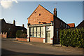
1
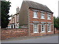
Sutton-on-Trent - Vine House
On Main Street.
Image: © Dave Bevis
Taken: 25 Aug 2010
0.05 miles
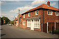
2
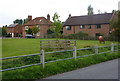
Houses by the High Street, Sutton on Trent
The High Street runs east from close to the church, with some open ground on the left before more houses.
Image: © Andrew Hill
Taken: 18 Sep 2010
0.05 miles
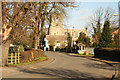
3
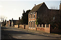
Main Street
View south along Main Street with Vine House http://www.geograph.org.uk/photo/2036669 on the right
Image: © Richard Croft
Taken: 4 Feb 2013
0.05 miles
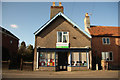
4
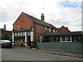
Deli and Coffee Hut, Sutton on Trent
Image: © Jonathan Thacker
Taken: 5 Nov 2021
0.05 miles
5
Oak Tree Farm Butchery
Buckham's Butchery & Farm Shop on Main Street, purveyors of wonderful meats and produce from Oak Tree Farm http://www.trentsidesaddlebacks.co.uk/
Image: © Richard Croft
Taken: 4 Feb 2013
0.05 miles
6
Sutton-on-Trent library
Village library in a former shop on Main Street
Image: © Richard Croft
Taken: 4 Feb 2013
0.06 miles
7
Woolfit House
Main Street Sutton-on-Trent with Woolfit house, formerly Woolfitt's Grocery shop
Image: © Richard Croft
Taken: 27 May 2013
0.08 miles
8
Main Street
View north along Main Street towards Church Street and All Saints' church http://www.geograph.org.uk/photo/3181709
Image: © Richard Croft
Taken: 4 Feb 2013
0.08 miles
9
Sutton-on-Trent Holmes
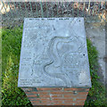
Cast panel on Main Street describing the Holmes of Sutton-on-Trent. These are the riverside meadows alongside the River Trent which are still grazed under agreements going back to the medieval period. The presence of land on the east bank of the river may well indicate an origin of the tradition predating the major changes to the course of the River Trent following flooding in the 13th/14th century.
The Holmes can be easily identified on the 25k OS maps as they are marked as Open Access Land. The panel was created for the 2000 millennium.
Image: © Alan Murray-Rust
Taken: 24 Jul 2014
0.08 miles
10
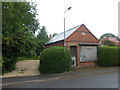
Unused building
A datestone says 1905. Was this once a village shop?
Image: © Graham Hogg
Taken: 13 Jul 2015
0.09 miles