IMAGES TAKEN NEAR TO
Moorlands Close, NEWARK, NG23 6LE
Introduction
This page details the photographs taken nearby to Moorlands Close, NG23 6LE by members of the Geograph project.
The Geograph project started in 2005 with the aim of publishing, organising and preserving representative images for every square kilometre of Great Britain, Ireland and the Isle of Man.

There are currently over 7.5m images from over14,400 individuals and you can help contribute to the project by visiting https://www.geograph.org.uk
Image Map
Images are licensed for reuse under creativecommons.org/licenses/by-sa/2.0
Notes
- Clicking on the map will re-center to the selected point.
- The higher the marker number, the further away the image location is from the centre of the postcode.
Image Listing (35 Images Found)
Images are licensed for reuse under creativecommons.org/licenses/by-sa/2.0
Image
Details
Distance
2
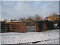
The Allotments at Norwell
The composting bins are prominent in this photograph.
Image: © Jonathan Thacker
Taken: 23 Dec 2010
0.06 miles
3
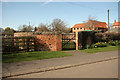
Norwell pinfold
Restored, grade II listed, 18th century pinfold in Norwell
Image: © Richard Croft
Taken: 25 Mar 2012
0.07 miles
4
Norwell pinfold
18th century circular pinfold or pound. Thought to be the largest circular pinfold in Nottinghamshire. Listed Grade II.
Image: © Alan Murray-Rust
Taken: 1 Aug 2014
0.07 miles
5
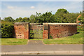
Norwell Pinfold
Grade II listed pinfold c1830 on Bathley Road, at 10m diameter, it is reputedly the largest circular pinfold in Nottinghamshire
Image: © Richard Croft
Taken: 4 Jun 2015
0.07 miles
6
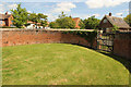
Norwell Pinfold
Inside Norwell Pinfold http://www.geograph.org.uk/photo/4512783 , Grade II listed pinfold c1830 on Bathley Road, at 10m diameter, it is reputedly the largest circular pinfold in Nottinghamshire
Image: © Richard Croft
Taken: 4 Jun 2015
0.07 miles
7
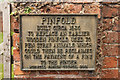
Norwell Pinfold plaque
Plaque on Norwell Pinfold http://www.geograph.org.uk/photo/4512783
Image: © Richard Croft
Taken: 4 Jun 2015
0.07 miles
8
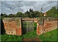
The circular pinfold in Norwell
This brick pinfold was built around 1830 to replace an earlier wooden pinfold. I know this because that is what the plaque explains. See https://www.geograph.org.uk/photo/4512798
Image: © Neil Theasby
Taken: 7 Oct 2020
0.07 miles
9
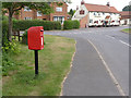
Bathley Lane, Norwell postbox ref NG23 222
Standard EIIR lamp box on pole.
Image: © Alan Murray-Rust
Taken: 1 Aug 2014
0.08 miles
10
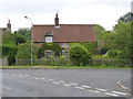
Scott's Cottage, Norwell
17th century timber framed cottage with brick cladding, well covered by climbing plants. Listed Grade II.
Image: © Alan Murray-Rust
Taken: 1 Aug 2014
0.08 miles