IMAGES TAKEN NEAR TO
Micklebarrow Hill, NEWARK, NG23 5RS
Introduction
This page details the photographs taken nearby to Micklebarrow Hill, NG23 5RS by members of the Geograph project.
The Geograph project started in 2005 with the aim of publishing, organising and preserving representative images for every square kilometre of Great Britain, Ireland and the Isle of Man.

There are currently over 7.5m images from over14,400 individuals and you can help contribute to the project by visiting https://www.geograph.org.uk
Image Map
Images are licensed for reuse under creativecommons.org/licenses/by-sa/2.0
Notes
- Clicking on the map will re-center to the selected point.
- The higher the marker number, the further away the image location is from the centre of the postcode.
Image Listing (14 Images Found)
Images are licensed for reuse under creativecommons.org/licenses/by-sa/2.0
Image
Details
Distance
1
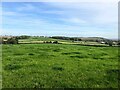
View from Micklebarrow Hill
Looking in the broad direction of Kelham from a spot near the hill's summit close to Micklebarrow House.
Image: © Jonathan Clitheroe
Taken: 18 Oct 2023
0.09 miles
2
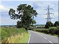
Power Lines Crossing the A617 near Micklebarrow Hill
Image: © David Dixon
Taken: 4 Aug 2014
0.09 miles
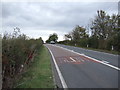
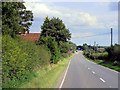
3
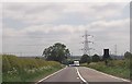
A617 approaching power lines near Micklebarrow Hill
Image: © John Firth
Taken: 9 Jun 2013
0.09 miles
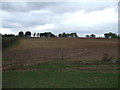
5
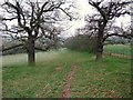
Track down Micklebarrow Hill
The pastured north side of the hill is more attractive than the cultivated southern approach. Following this track has led me off the Trent Valley Way, which runs slightly to the left of the picture.
Image: © Tim Heaton
Taken: 30 Dec 2008
0.14 miles
8
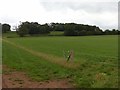
Micklebarrow Hill
A glaciated outlier on the edge of the Trent Valley.
Image: © Alan Murray-Rust
Taken: 23 Aug 2020
0.16 miles
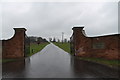
10
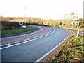
A617 Junction to Averham Park
View is looking West.
Image: © Geoff Dunn
Taken: 7 Feb 2006
0.21 miles