IMAGES TAKEN NEAR TO
Fosse Road, NEWARK, NG23 5NQ
Introduction
This page details the photographs taken nearby to Fosse Road, NG23 5NQ by members of the Geograph project.
The Geograph project started in 2005 with the aim of publishing, organising and preserving representative images for every square kilometre of Great Britain, Ireland and the Isle of Man.

There are currently over 7.5m images from over14,400 individuals and you can help contribute to the project by visiting https://www.geograph.org.uk
Image Map
Images are licensed for reuse under creativecommons.org/licenses/by-sa/2.0
Notes
- Clicking on the map will re-center to the selected point.
- The higher the marker number, the further away the image location is from the centre of the postcode.
Image Listing (7 Images Found)
Images are licensed for reuse under creativecommons.org/licenses/by-sa/2.0
Image
Details
Distance
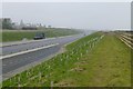
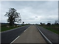
2
Road works
Realignment and dualling of the A46 Fosse Way near Syerston village.
Image: © James Allan
Taken: 24 Sep 2010
0.19 miles
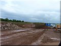
4
New A46 near Syerston
Looking towards Newark from the road into Syerston. At this point the new road diverges quite considerably from the old alignment, mainly to skirt the village of East Stoke and the scheduled ancient monument Roman site of Ad Pontem.
Image: © Alan Murray-Rust
Taken: 8 Dec 2009
0.20 miles
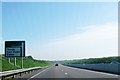
5
New road towards Syerston village
A bridge takes it over the newly opened A46.
Image: © JThomas
Taken: 7 Apr 2012
0.23 miles
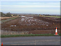
6
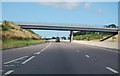
A46 road bridge near Syerston
Main Street runs over the bridge.
Image: © J.Hannan-Briggs
Taken: 18 Jul 2015
0.24 miles
7
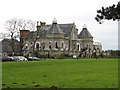
Elston Towers
Elston Towers has a very varied past, and in its latest guise is better known as "Eden Hall Day Spa".
http://www.edenspa.co.uk/about-us
Image: © Bob Danylec
Taken: 27 Nov 2005
0.25 miles