IMAGES TAKEN NEAR TO
Coneygrey Spinney, NEWARK, NG23 5LN
Introduction
This page details the photographs taken nearby to Coneygrey Spinney, NG23 5LN by members of the Geograph project.
The Geograph project started in 2005 with the aim of publishing, organising and preserving representative images for every square kilometre of Great Britain, Ireland and the Isle of Man.

There are currently over 7.5m images from over14,400 individuals and you can help contribute to the project by visiting https://www.geograph.org.uk
Image Map
Images are licensed for reuse under creativecommons.org/licenses/by-sa/2.0
Notes
- Clicking on the map will re-center to the selected point.
- The higher the marker number, the further away the image location is from the centre of the postcode.
Image Listing (29 Images Found)
Images are licensed for reuse under creativecommons.org/licenses/by-sa/2.0
Image
Details
Distance
1
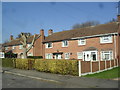
Coneygrey Spinney
1950s Ex-Royal Air Force personnel semis in Flintham.
Image: © Burgess Von Thunen
Taken: 19 Feb 2013
0.05 miles
2
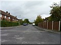
Airmens' quarters
Formerly housing for service personnel stationed at RAF Syerston this has now been transformed into Coneygrey Spinney, a village street just off the A46 road.
Image: © James Allan
Taken: 24 Sep 2010
0.05 miles
3
Coney Grey Spinney
Post-war housing associated with the adjacent RAF Syerston. Now in private ownership.
Image: © Alan Murray-Rust
Taken: 6 Dec 2009
0.06 miles
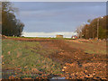
4
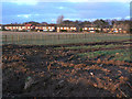
Coney Grey Spinney
Post-war housing associated with the adjacent RAF Syerston. Now in private ownership. In the foreground the land that will be taken up by the widened A46.
Image: © Alan Murray-Rust
Taken: 6 Dec 2009
0.08 miles
5
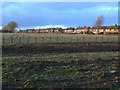
Coney Grey Spinney
Post-war housing associated with the adjacent RAF Syerston. Now in private ownership. In the foreground the land that will be taken up by the widened A46.
Image: © Alan Murray-Rust
Taken: 6 Dec 2009
0.10 miles
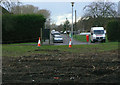
6
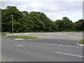
Bus turnround, Coneygrey Spinney
The widening of the A46 resulted in the original access to the housing off the old road being severed, and eliminating bus stops. As a replacement, there is a new road link http://www.geograph.org.uk/photo/3138371, and a new bus turnround has been created on the base of a former airfield building, possibly a hangar from the size of the door runs still visible.
Image: © Alan Murray-Rust
Taken: 14 Sep 2012
0.12 miles
7
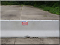
Warning - do not work or walk within 1.2m of this barrier
The barrier was originally used as a temporary barrier alongside the carriageway during the reconstruction of the A46, and has been moved complete with notice to form part of the boundary to the new bus turn round at Coneygrey Spinney http://www.geograph.org.uk/photo/3138370
Image: © Alan Murray-Rust
Taken: 14 Sep 2012
0.13 miles
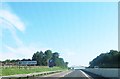
8
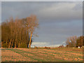
Site of the new A46
The existing road can be seen at the right, but this view shows the extent of woodland that has been cleared for the widened road. A final burst of sunshine cut through below a bank of cloud to cast a warm light on the landscape. Taken from the lane to Trent Hills Farm.
Image: © Alan Murray-Rust
Taken: 6 Dec 2009
0.14 miles
9
Site of the new A46
The existing road can be seen at the right, but this view shows the extent of woodland that has been cleared for the widened road.
Image: © Alan Murray-Rust
Taken: 6 Dec 2009
0.14 miles