IMAGES TAKEN NEAR TO
Claypole Road, NEWARK, NG23 5BU
Introduction
This page details the photographs taken nearby to Claypole Road, NG23 5BU by members of the Geograph project.
The Geograph project started in 2005 with the aim of publishing, organising and preserving representative images for every square kilometre of Great Britain, Ireland and the Isle of Man.

There are currently over 7.5m images from over14,400 individuals and you can help contribute to the project by visiting https://www.geograph.org.uk
Image Map
Images are licensed for reuse under creativecommons.org/licenses/by-sa/2.0
Notes
- Clicking on the map will re-center to the selected point.
- The higher the marker number, the further away the image location is from the centre of the postcode.
Image Listing (25 Images Found)
Images are licensed for reuse under creativecommons.org/licenses/by-sa/2.0
Image
Details
Distance
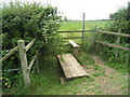
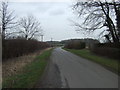
1
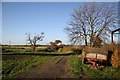
Footpath to Claypole
Track from Stubton to Claypole
Image: © Richard Croft
Taken: 18 Nov 2006
0.08 miles
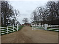
3
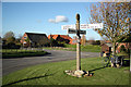
Stubton Crossroads
Central Stubton with a welcome bench for a cyclist to take a rest and eat some lunch
Image: © Richard Croft
Taken: 13 Nov 2010
0.11 miles
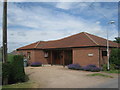
5
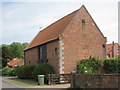
Barn conversion, Stubton
This was part of Home Farm which was largely destroyed by an air crash in March 1962. http://stubtonvillage.com/History_of_Stubton_Village/
Image: © Jonathan Thacker
Taken: 2 Jul 2010
0.14 miles
10
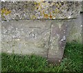
Ordnance Survey Cut Mark
This OS cut mark can be found on the north face of St Martin's Church. It marks a point 27.258m above mean sea level.
Image: © Adrian Dust
Taken: 5 Jun 2016
0.22 miles