IMAGES TAKEN NEAR TO
Sandays Close, NOTTINGHAM, NG2 2NP
Introduction
This page details the photographs taken nearby to Sandays Close, NG2 2NP by members of the Geograph project.
The Geograph project started in 2005 with the aim of publishing, organising and preserving representative images for every square kilometre of Great Britain, Ireland and the Isle of Man.

There are currently over 7.5m images from over14,400 individuals and you can help contribute to the project by visiting https://www.geograph.org.uk
Image Map
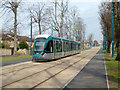
Images are licensed for reuse under creativecommons.org/licenses/by-sa/2.0
Notes
- Clicking on the map will re-center to the selected point.
- The higher the marker number, the further away the image location is from the centre of the postcode.
Image Listing (358 Images Found)
Images are licensed for reuse under creativecommons.org/licenses/by-sa/2.0
Image
Details
Distance
1
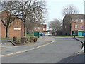
Sweet Leys Road
1970s development on the site of old railway sidings.
Image: © Alan Murray-Rust
Taken: 20 Mar 2009
0.04 miles
2
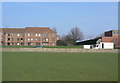
Part of Carroll Close
This new housing was built on land formerly occupied by the Great Central Railway main line and its sidings. The viewpoint would have been directly under the bridge crossing the Trent. There is no sign at all on this side of the river of the railway now until reaching the Station Street Tram Terminus.
Image: © Alan Murray-Rust
Taken: 20 Mar 2009
0.06 miles
3
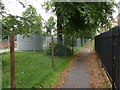
Reduced footway
Much of Queen's Walk has been fenced off for construction work.
Image: © Alan Murray-Rust
Taken: 23 Aug 2012
0.07 miles
4
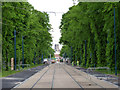
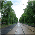
Queen's Walk
Despite the felling of a number of the original lime trees as part of the tramway project, this remains a fine avenue.
Image: © Alan Murray-Rust
Taken: 14 May 2014
0.07 miles
5
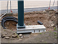
Offset overhead pole
For some reason the foundation for the pole has not been constructed directly below the pole, requiring a special bracket.
Image: © Alan Murray-Rust
Taken: 4 Apr 2014
0.07 miles
6
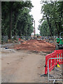
Queen's Walk: preparing the way for the trams
The route is being levelled ready for the concrete trackbase to be laid. The northern end of Wilford Toll Bridge is just visible in the centre.
Image: © John Sutton
Taken: 23 Aug 2013
0.07 miles
7
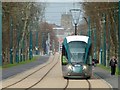
Tram approaching Meadows Embankment stop
The tower of St Mary's Church rises in the distance.
Image: © Alan Murray-Rust
Taken: 20 Mar 2015
0.07 miles
8
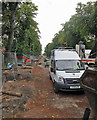
Queen's Walk: tramway construction
The trackbed between Wilford Toll Bridge and Robin Hood Way has been levelled but the concrete track base has not yet been laid.
Image: © John Sutton
Taken: 26 Sep 2013
0.07 miles
9
Tram on test, Queens Walk
Between Wilford Bridge and Robin Hood Way
Image: © Alan Murray-Rust
Taken: 11 Mar 2015
0.07 miles
10
Queen's Walk: waiting for the wires
A view towards the city from just north of where the Queen's Walk tram stop will be. The track, roadway and footpaths are complete and the poles in place, but the wires have yet to be strung.
See Image] for the state of play in August 2012 and Image] for how things were just over a year before.
Image: © John Sutton
Taken: 11 May 2014
0.08 miles