IMAGES TAKEN NEAR TO
Arkwright Walk, NOTTINGHAM, NG2 2LP
Introduction
This page details the photographs taken nearby to Arkwright Walk, NG2 2LP by members of the Geograph project.
The Geograph project started in 2005 with the aim of publishing, organising and preserving representative images for every square kilometre of Great Britain, Ireland and the Isle of Man.

There are currently over 7.5m images from over14,400 individuals and you can help contribute to the project by visiting https://www.geograph.org.uk
Image Map
Images are licensed for reuse under creativecommons.org/licenses/by-sa/2.0
Notes
- Clicking on the map will re-center to the selected point.
- The higher the marker number, the further away the image location is from the centre of the postcode.
Image Listing (918 Images Found)
Images are licensed for reuse under creativecommons.org/licenses/by-sa/2.0
Image
Details
Distance
1
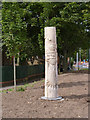
Story Pole 1: 'Welcome to the Meadows'
Near the top of Arkwright Walk, where the tramway enters the Meadows.
Image: © Alan Murray-Rust
Taken: 14 Aug 2014
0.01 miles
2
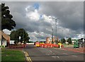
Meadows Way: road closed for tramway works
A Bridgford-bound bus is coming down what remains of Arkwright Street, which was the principal route through The Meadows until the Victorian street pattern was obliterated by the redevelopment of the 1970s.
Image: © John Sutton
Taken: 11 Sep 2012
0.01 miles
3
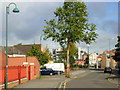
Arkwright Walk, The Meadows
Arkwright Walk is a short stub of a street on the alignment of the old Arkwright Street, now cut short by a modern church building where the street used to run. It is hard to believe that until the 1970s this was a busy main route into the city, lined with shops.
Image: © Stephen McKay
Taken: 25 Sep 2007
0.01 miles
4
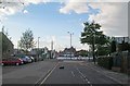
Cat crossing Arkwright Walk
Looking towards the city on a May evening. Fifty years ago there were three-storey Victorian shops either side of the road and the former Great Central Railway from Nottingham Victoria to Marylebone crossed on a plate girder bridge which carried a prominent advertisement for Oscroft's of Castle Boulevard, Vauxhall and Bedford dealers. Arkwright Street Station (see David Hillas's Image]) was to the left, approached by a stairway.
Image: © John Sutton
Taken: 15 May 2013
0.01 miles
5
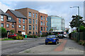
On Arkwright Walk
The former Arkwright Street, once busy with buses, trolleybuses, cars and lorries, has been largely pedestrianised since the 1970s. The large new building in the middle distance is Unity Square, opposite the railway station (in Image), a regional centre for HM Revenue and Customs. For comparison, see Image] (July 2019).
Image: © John Sutton
Taken: 5 Jul 2021
0.01 miles
6
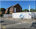
Building new houses on Arkwright Walk
Much of the Victorian housing in The Meadows was replaced in the 1970s. A new phase of building was going on in 2018.
Image: © John Sutton
Taken: 26 Jun 2018
0.01 miles
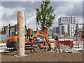
7
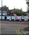
Tramway construction site at Meadows Way
On the skyline are the domes of the railway station (left) and The Council House - visible from here since buildings on Arkwright Street were demolished in 2012. The man in the tracksuit looked to be wondering why I was taking a picture.
Image: © John Sutton
Taken: 15 May 2013
0.01 miles
8
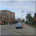
At the city end of Arkwright Walk
The houses on the left have replaced those built in the 1970s when The Meadows was redeveloped and a lot of Victorian slum houses demolished. The cranes are on the former car park site between Sheriffs Way and the railway.
Image: © John Sutton
Taken: 1 Jul 2019
0.02 miles
9
Story Pole 1: 'Welcome to the Meadows'
Near the top of Arkwright Walk, where the tramway enters the Meadows.
Image: © Alan Murray-Rust
Taken: 14 Aug 2014
0.02 miles
10
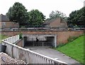
Subway under Meadows Way
The camera is pointing along what was once the alignment of the Great Central Railway from Nottingham Victoria to London Marylebone, which crossed the Meadows at roof height on arches and embankments. This was the site of Arkwright Street Station, which closed in 1969 - see David Hillas's Image], a photo pointing towards where I stood to take this picture. David was at about tree-top level.
Image: © John Sutton
Taken: 18 Jul 2012
0.02 miles