IMAGES TAKEN NEAR TO
Bathley Street, NOTTINGHAM, NG2 2LH
Introduction
This page details the photographs taken nearby to Bathley Street, NG2 2LH by members of the Geograph project.
The Geograph project started in 2005 with the aim of publishing, organising and preserving representative images for every square kilometre of Great Britain, Ireland and the Isle of Man.

There are currently over 7.5m images from over14,400 individuals and you can help contribute to the project by visiting https://www.geograph.org.uk
Image Map
Images are licensed for reuse under creativecommons.org/licenses/by-sa/2.0
Notes
- Clicking on the map will re-center to the selected point.
- The higher the marker number, the further away the image location is from the centre of the postcode.
Image Listing (415 Images Found)
Images are licensed for reuse under creativecommons.org/licenses/by-sa/2.0
Image
Details
Distance
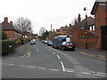
1
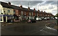
Corner shop and terraced houses - Bathley Street
Image: © David Lally
Taken: 5 May 2015
0.01 miles
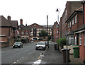
2
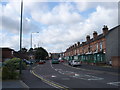
The Meadows, Nottingham
The Meadows area was extensively redeveloped in the 70s, with large swathes of old housing being demolished. Some of the older housing was, however, retained, and this street scene shows the old meeting the new, with the older houses on the right-hand side of the road, and the newer on the left.
Image: © Oxymoron
Taken: 3 Sep 2008
0.03 miles
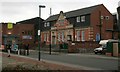
3
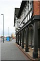
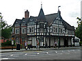
The Embankment Club
Former Boots Institute and shop in mock Tudor style now converted into a business and social club. It was built around 1907 as a chemist's shop and the Olde English Café. In 1922 the shop part developed into Boots's social club with the addition of billiard room, lounge and dance hall.
Image: © Mick Garratt
Taken: 7 Nov 2007
0.04 miles
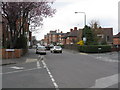
5
Turney Street on a damp afternoon
One of many drab days in the disappointing summer of 2012. The former Turney Brothers' Trent Bridge Leather Works, now flats, is the four-storey building in the distance.
Image: © John Sutton
Taken: 20 Jul 2012
0.07 miles
6
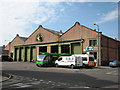
Trent Bridge Bus Depot, Bunbury Street
Originally built in 1902 as a works for the Nottingham Corporation tram system, the Bunbury Street building then serviced trolleybuses until 1965. The doorways are tall enough to take double-deckers and the tram and trolleybus overhead wires.
Image: © John Sutton
Taken: 1 Jul 2009
0.07 miles
8
Portland Leisure Centre
The Portland Swimming Baths date from 1914 and was adjacent to the tram depot which has now been incorporated into the modern leisure centre.
Image: © Mick Garratt
Taken: 7 Nov 2007
0.08 miles
9

Bus depots on Turney Street
Nottingham City Transport's Trent Bridge Works (right) was built for its first-generation electric trams, and by the 1930s housed and maintained its large trolleybus fleet as well as diesel buses.
Image: © John Sutton
Taken: 15 Apr 2022
0.09 miles
10
The Embankment, London Road, Nottingham
Formerly a Boots shop and tea rooms by the company's resident architect, A.N. Bromley, 1905.
In a reversal of the usual process, it is now a pub.
Image: © Stephen Richards
Taken: 25 Jun 2015
0.09 miles