IMAGES TAKEN NEAR TO
Turney Street, NOTTINGHAM, NG2 2LG
Introduction
This page details the photographs taken nearby to Turney Street, NG2 2LG by members of the Geograph project.
The Geograph project started in 2005 with the aim of publishing, organising and preserving representative images for every square kilometre of Great Britain, Ireland and the Isle of Man.

There are currently over 7.5m images from over14,400 individuals and you can help contribute to the project by visiting https://www.geograph.org.uk
Image Map
Images are licensed for reuse under creativecommons.org/licenses/by-sa/2.0
Notes
- Clicking on the map will re-center to the selected point.
- The higher the marker number, the further away the image location is from the centre of the postcode.
Image Listing (459 Images Found)
Images are licensed for reuse under creativecommons.org/licenses/by-sa/2.0
Image
Details
Distance
1
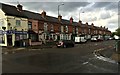
Corner shop and terraced houses - Bathley Street
Image: © David Lally
Taken: 5 May 2015
0.03 miles
4
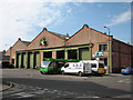
Trent Bridge Bus Depot, Bunbury Street
Originally built in 1902 as a works for the Nottingham Corporation tram system, the Bunbury Street building then serviced trolleybuses until 1965. The doorways are tall enough to take double-deckers and the tram and trolleybus overhead wires.
Image: © John Sutton
Taken: 1 Jul 2009
0.05 miles
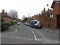
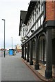
5
Turney Street on a damp afternoon
One of many drab days in the disappointing summer of 2012. The former Turney Brothers' Trent Bridge Leather Works, now flats, is the four-storey building in the distance.
Image: © John Sutton
Taken: 20 Jul 2012
0.05 miles
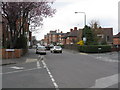
7
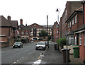
The Meadows, Nottingham
The Meadows area was extensively redeveloped in the 70s, with large swathes of old housing being demolished. Some of the older housing was, however, retained, and this street scene shows the old meeting the new, with the older houses on the right-hand side of the road, and the newer on the left.
Image: © Oxymoron
Taken: 3 Sep 2008
0.06 miles
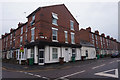
8
The Embankment Club
Former Boots Institute and shop in mock Tudor style now converted into a business and social club. It was built around 1907 as a chemist's shop and the Olde English Café. In 1922 the shop part developed into Boots's social club with the addition of billiard room, lounge and dance hall.
Image: © Mick Garratt
Taken: 7 Nov 2007
0.06 miles
9
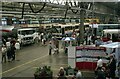
City of Nottingham Transport Open Day at Trent Bridge Works – 1986
The impetus behind the open day was to ensure local interest among the public in maintaining locally owned bus services following the removal of bus service licencing under the 1985 Transport Act. As well as the undertaking’s own vehicles (the green and cream buses), vehicles from other organisations were also on display. In the centre is a new articulated bus for South Yorkshire Transport in Sheffield, to the right a preserved pre-war Trent Motor Traction single decker and to the left an articulated tanker from the undertaking’s fuel supplier’s fleet.
The works building was built in 1901 as a combined running shed and repair facility for the city's electric trams. It served subsequently for some time as a bus garage before being re-purposed as the main overhaul facility for the undertaking's bus fleet. It is still (2024) in use as such. The building is Listed Grade II.
Image: © Alan Murray-Rust
Taken: 8 Jun 1986
0.07 miles
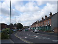
10
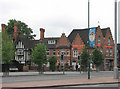
Victoria Embankment joins London Road
The Topknot Hair and Beauty establishment, with its crow-stepped gables and vaguely Baltic look, has been a Trent Bridge landmark for a century, in former times carrying a large advertisement for Pork Farms pork pies. The half-timbered house to the left is the first of the rather grand Edwardian houses on Fraser Road which back on to Victoria Embankment. In the days of trolleybuses, this was the stop for the 45 Trent Bridge to Wollaton service, which, like the 41 Cinderhill and 43 Bulwell Market terminated and turned just to the left of here, on the Embankment, where the majority of the city-bound stops were.
Image: © John Sutton
Taken: 31 May 2010
0.08 miles