IMAGES TAKEN NEAR TO
Kenton Court, NOTTINGHAM, NG2 2JL
Introduction
This page details the photographs taken nearby to Kenton Court, NG2 2JL by members of the Geograph project.
The Geograph project started in 2005 with the aim of publishing, organising and preserving representative images for every square kilometre of Great Britain, Ireland and the Isle of Man.

There are currently over 7.5m images from over14,400 individuals and you can help contribute to the project by visiting https://www.geograph.org.uk
Image Map
Images are licensed for reuse under creativecommons.org/licenses/by-sa/2.0
Notes
- Clicking on the map will re-center to the selected point.
- The higher the marker number, the further away the image location is from the centre of the postcode.
Image Listing (256 Images Found)
Images are licensed for reuse under creativecommons.org/licenses/by-sa/2.0
Image
Details
Distance
1
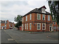
The Meadows: the former Plumptre Arms
The building on the corner of Muskham Street and Bunbury Street was originally one of many pubs in The Meadows.
Image: © John Sutton
Taken: 1 Jul 2019
0.05 miles
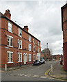
2
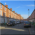
Along Wilford Crescent East
Three-storey terraces of a type built all over Nottingham in the late 19th century, photographed on a bright September morning.
Image: © John Sutton
Taken: 13 Sep 2019
0.06 miles
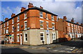
3
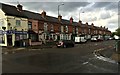
Corner shop and terraced houses - Bathley Street
Image: © David Lally
Taken: 5 May 2015
0.06 miles
4
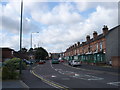
The Meadows, Nottingham
The Meadows area was extensively redeveloped in the 70s, with large swathes of old housing being demolished. Some of the older housing was, however, retained, and this street scene shows the old meeting the new, with the older houses on the right-hand side of the road, and the newer on the left.
Image: © Oxymoron
Taken: 3 Sep 2008
0.07 miles
6
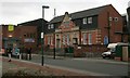
Portland Leisure Centre
The Portland Swimming Baths date from 1914 and was adjacent to the tram depot which has now been incorporated into the modern leisure centre.
Image: © Mick Garratt
Taken: 7 Nov 2007
0.07 miles
7

Benchmark on boundary wall of #84 Wilford Cresecent East
Ordnance Survey cut mark benchmark described on the Bench Mark Database at www.bench-marks.org.uk/bm112058
Image: © Luke Shaw
Taken: 11 May 2019
0.08 miles
8
Houses at the junction of Bathley Street and Wilford Crescent East
There is an OS benchmark Image on the roadside wall at the back of the house at the corner
Image: © Luke Shaw
Taken: 11 May 2019
0.08 miles
9
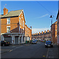
On Wilford Crescent East
The corners of Holgate Road and Muskham Street on a bright September morning. The white cranes on the skyline are on the Unity Square site near Nottingham railway station which is shown in Image] and Image
Image: © John Sutton
Taken: 13 Sep 2019
0.08 miles
10
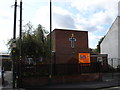
The Full Gospel Revival Centre, Bathley Street
Compare the scale of this new(ish) church with that of the older church just up the road [http://www.geograph.org.uk/photo/948761].
Image: © Oxymoron
Taken: 3 Sep 2008
0.09 miles