IMAGES TAKEN NEAR TO
Bridgeway Centre, NOTTINGHAM, NG2 2JG
Introduction
This page details the photographs taken nearby to Bridgeway Centre, NG2 2JG by members of the Geograph project.
The Geograph project started in 2005 with the aim of publishing, organising and preserving representative images for every square kilometre of Great Britain, Ireland and the Isle of Man.

There are currently over 7.5m images from over14,400 individuals and you can help contribute to the project by visiting https://www.geograph.org.uk
Image Map
Images are licensed for reuse under creativecommons.org/licenses/by-sa/2.0
Notes
- Clicking on the map will re-center to the selected point.
- The higher the marker number, the further away the image location is from the centre of the postcode.
Image Listing (657 Images Found)
Images are licensed for reuse under creativecommons.org/licenses/by-sa/2.0
Image
Details
Distance
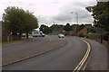
1
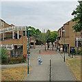
The Meadows: Bridgeway Centre
A 1970s shopping centre in the Meadows district of Nottingham, seen from above the subway under Sheriffs Way on a cloudy July morning.
Image: © John Sutton
Taken: 28 Jul 2022
0.03 miles
2
Bridgeway Centre
The main local shopping centre for the Meadows.
Image: © Alan Murray-Rust
Taken: 21 Mar 2013
0.04 miles
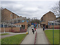
3
The Meadows: Bridgeway Centre
A small shopping centre created when much of The Meadows was redeveloped in the 1970s. The picture was taken from Sheriffs Way before the shops opened on a sunny mid-September morning.
Image: © John Sutton
Taken: 13 Sep 2019
0.04 miles
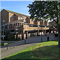
4
Bridgeway Centre, The Meadows
The Meadows was an area of cheaply-built Victorian terraced housing situated on Nottingham's floodplain between the River Trent and the city centre. The area flooded seriously in 1947, although flood defences built in the 1950s have prevented a repeat. The area was comprehensively redeveloped in the 1970s, destroying the original street plan and the main thoroughfare - Arkwright Street. As so often with such comprehensive schemes, many people would say that the sense of community was swept away with the old houses. In the new scheme this shopping centre forms the centrepiece, and while it may not be very attractive visually, there is a range of independent shops that would do many more affluent suburbs proud.
Image: © Stephen McKay
Taken: 25 Sep 2007
0.05 miles
6
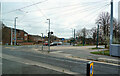
The Meadows
A curving road and tramway near the Meadows.
Image: © Malcolm Neal
Taken: 24 Nov 2021
0.07 miles
7
Tram tracks on Meadows Way
Both tracks are laid and the road surface is in the course of being added.
Image: © Alan Murray-Rust
Taken: 2 Feb 2014
0.07 miles
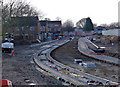
8
Lowering Meadows Way for the tram
The road is being lowered to the level of the land to the left. The tram routes will divide at the top of Queen's Walk.
Image: © John Sutton
Taken: 30 Apr 2013
0.07 miles
9
Tram tracks in Meadows Way
The tracks and the overhead poles are in place, the road surface has been restored and the road is in use. Image] shows the state of play two months before.
Image: © John Sutton
Taken: 7 Apr 2014
0.07 miles
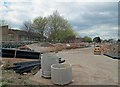
10

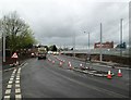
Road to be closed
This will enable reconstruction of the road layout at the junction ahead to allow for new tramlines.
Image: © Alan Murray-Rust
Taken: 30 Jul 2012
0.07 miles