IMAGES TAKEN NEAR TO
Bridgeway Centre, NOTTINGHAM, NG2 2JD
Introduction
This page details the photographs taken nearby to Bridgeway Centre, NG2 2JD by members of the Geograph project.
The Geograph project started in 2005 with the aim of publishing, organising and preserving representative images for every square kilometre of Great Britain, Ireland and the Isle of Man.

There are currently over 7.5m images from over14,400 individuals and you can help contribute to the project by visiting https://www.geograph.org.uk
Image Map
Images are licensed for reuse under creativecommons.org/licenses/by-sa/2.0
Notes
- Clicking on the map will re-center to the selected point.
- The higher the marker number, the further away the image location is from the centre of the postcode.
Image Listing (548 Images Found)
Images are licensed for reuse under creativecommons.org/licenses/by-sa/2.0
Image
Details
Distance
1
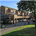
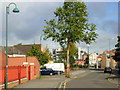
The Meadows: Bridgeway Centre
A small shopping centre created when much of The Meadows was redeveloped in the 1970s. The picture was taken from Sheriffs Way before the shops opened on a sunny mid-September morning.
Image: © John Sutton
Taken: 13 Sep 2019
0.01 miles
2
Bridgeway Centre
The main local shopping centre for the Meadows.
Image: © Alan Murray-Rust
Taken: 21 Mar 2013
0.02 miles
3
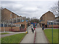
The Meadows: Bridgeway Centre
A 1970s shopping centre in the Meadows district of Nottingham, seen from above the subway under Sheriffs Way on a cloudy July morning.
Image: © John Sutton
Taken: 28 Jul 2022
0.03 miles
4
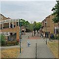
Bridgeway Centre, The Meadows
The Meadows was an area of cheaply-built Victorian terraced housing situated on Nottingham's floodplain between the River Trent and the city centre. The area flooded seriously in 1947, although flood defences built in the 1950s have prevented a repeat. The area was comprehensively redeveloped in the 1970s, destroying the original street plan and the main thoroughfare - Arkwright Street. As so often with such comprehensive schemes, many people would say that the sense of community was swept away with the old houses. In the new scheme this shopping centre forms the centrepiece, and while it may not be very attractive visually, there is a range of independent shops that would do many more affluent suburbs proud.
Image: © Stephen McKay
Taken: 25 Sep 2007
0.04 miles
5
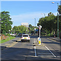
Rush-hour traffic on Sheriffs Way
A view taken from a pedestrian refuge at the corner of Robin Hood Way, with Nottingham Castle, shrouded in scaffolding during a multi-million-pound restoration, on the skyline to the left of centre.
Image: © John Sutton
Taken: 13 Sep 2019
0.06 miles
6
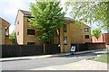
Houses of Bridgeway Court, Arkwright Walk
There is an Ordnance Survey benchmark Image on the front of the house in bricks right of the left hand wooden fence
Image: © Luke Shaw
Taken: 11 May 2019
0.07 miles
7
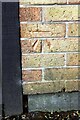
Benchmark on #18 Bridgeway Court, Arkwright Walk
Ordnance Survey cut mark benchmark described on the Bench Mark Database at www.bench-marks.org.uk/bm114992
Image: © Luke Shaw
Taken: 11 May 2019
0.07 miles
8
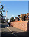
Near the north end of Arkwright Walk
A warm and sunny September afternoon. The crane is on the Unity Square building site opposite Nottingham railway station.
Image: © John Sutton
Taken: 19 Sep 2019
0.08 miles
9
Arkwright Walk, The Meadows
Arkwright Walk is a short stub of a street on the alignment of the old Arkwright Street, now cut short by a modern church building where the street used to run. It is hard to believe that until the 1970s this was a busy main route into the city, lined with shops.
Image: © Stephen McKay
Taken: 25 Sep 2007
0.08 miles
10
Building new houses on Arkwright Walk
Much of the Victorian housing in The Meadows was replaced in the 1970s. A new phase of building was going on in 2018.
Image: © John Sutton
Taken: 26 Jun 2018
0.08 miles