IMAGES TAKEN NEAR TO
School Close, NOTTINGHAM, NG2 2GG
Introduction
This page details the photographs taken nearby to School Close, NG2 2GG by members of the Geograph project.
The Geograph project started in 2005 with the aim of publishing, organising and preserving representative images for every square kilometre of Great Britain, Ireland and the Isle of Man.

There are currently over 7.5m images from over14,400 individuals and you can help contribute to the project by visiting https://www.geograph.org.uk
Image Map
Images are licensed for reuse under creativecommons.org/licenses/by-sa/2.0
Notes
- Clicking on the map will re-center to the selected point.
- The higher the marker number, the further away the image location is from the centre of the postcode.
Image Listing (180 Images Found)
Images are licensed for reuse under creativecommons.org/licenses/by-sa/2.0
Image
Details
Distance
1
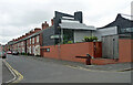
Collygate Road, Nottingham
Standard Victorian terraces interrupted by Julian Marsh's house for himself, built in 2007-08. The black cladding is zinc.
Image: © Stephen Richards
Taken: 19 Jun 2015
0.01 miles
2
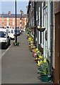
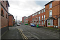
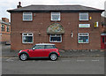
Flowered terrace
A concerted effort has been made in this one street (Collygate Road) to put on a fine display of blooms.
Image: © Alan Murray-Rust
Taken: 20 Mar 2009
0.02 miles
3
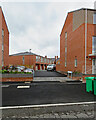
Felton Road
New housing recently built on the site of the former Mundella School.
Image: © Alan Murray-Rust
Taken: 20 Mar 2009
0.03 miles
4
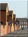
The Meadows: Measham Close
New housing at the southern end of Victorian Wilford Crescent East.
Image: © John Sutton
Taken: 5 May 2023
0.04 miles
5

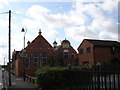
Former school buildings
Now the Meadows Muslim Centre, these buildings were once the local infants and junior school for the area before being absorbed into the former Mundella Grammar School, once the main grammar school for the south side of Nottingham. They were then used as Library and sixth form facilities. The initials NSB show that this was a foundation of the Nottingham Schools Board.
Image: © Alan Murray-Rust
Taken: 20 Mar 2009
0.04 miles
6
Meadows Muslim Centre, Collgate Road
It looks as though these buildings were once a local school, probably attached to the church next door on Bathley Street [http://www.geograph.org.uk/photo/948761].
Image: © Oxymoron
Taken: 3 Sep 2008
0.04 miles
7
Old and new on Wilford Crescent East
New housing at the southern end of Victorian Wilford Crescent in the Meadows district of Nottingham.
Image: © John Sutton
Taken: 5 May 2023
0.04 miles
8
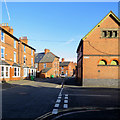
At the corner of Pyatt Street
Wilford Crescent East on a bright late-summer morning. A lot of The Meadows was demolished in the 1970s, but many of the better Victorian houses at the southern end remain.
Image: © John Sutton
Taken: 13 Sep 2019
0.04 miles
9
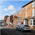
The Meadows: new and old on Wilford Crescent East
New houses going up near the southern edge of The Meadows.
Image: © John Sutton
Taken: 5 Jul 2021
0.05 miles
10
Meadows Youth and Community Centre
On the corner of Wilford Crescent and (left) Pyatt Street. The tympanum over what was once a door illustrates aspects of The Meadows district.
Image: © John Sutton
Taken: 23 Jul 2018
0.05 miles