IMAGES TAKEN NEAR TO
Old Rufford Road, NEWARK, NG22 8TP
Introduction
This page details the photographs taken nearby to Old Rufford Road, NG22 8TP by members of the Geograph project.
The Geograph project started in 2005 with the aim of publishing, organising and preserving representative images for every square kilometre of Great Britain, Ireland and the Isle of Man.

There are currently over 7.5m images from over14,400 individuals and you can help contribute to the project by visiting https://www.geograph.org.uk
Image Map
Images are licensed for reuse under creativecommons.org/licenses/by-sa/2.0
Notes
- Clicking on the map will re-center to the selected point.
- The higher the marker number, the further away the image location is from the centre of the postcode.
Image Listing (10 Images Found)
Images are licensed for reuse under creativecommons.org/licenses/by-sa/2.0
Image
Details
Distance
1
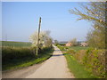
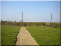
Lane south west of Bilsthorpe (1)
A designated byway leading to the A614.
Image: © Richard Vince
Taken: 30 Mar 2019
0.07 miles
3
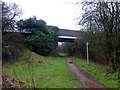
Bridge over the Southwell Trail
The bridge carries a byway open to all traffic over the Trail, a leisure route on the former Southwell - Mansfield railway.
Image: © Graham Hogg
Taken: 5 Jan 2016
0.12 miles
4

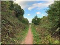
Southwell Trail
Southwell Trail http://www.nottinghamshire.gov.uk/enjoying/countryside/nature-reserves/southwell-trail/ in a cutting near Forest Lane bridge
Image: © Richard Croft
Taken: 20 Jun 2014
0.14 miles
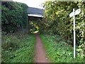
5
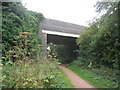
Forest Lane bridge
The Southwell Trail passes beneath Forest Lane. The Southwell Trail follows the course of the former LMS/LNER Joint railway from Farnsfield Junction to Ollerton. The line opened in 1931 and this section closed in 1963.
Image: © Jonathan Thacker
Taken: 30 Jul 2010
0.15 miles
6
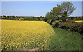
Public footpath south west of Bilsthorpe (3)
Approaching the edge of a field, from which it reaches a farm track by passing through a small gap in the hedge (which would be very hard to spot from the other side).
Image: © Richard Vince
Taken: 30 Mar 2019
0.17 miles
7
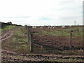
Free Range Pig Farm
on the corner of Forest Lane and Farnsfield Road
Image: © Tom Courtney
Taken: 2 Oct 2005
0.20 miles
8
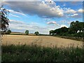
Crop Field near Bilsthorpe
Looking east towards the southern fringe of Bilsthorpe from the Southwell Trail.
Image: © Jonathan Clitheroe
Taken: 26 Aug 2022
0.20 miles
10
The Southwell Trail Between Farnsfield and Bilsthorpe
Former branch line passing through a cutting near Kirklington Road.
Image: © Jonathan Clitheroe
Taken: 26 Aug 2022
0.24 miles