IMAGES TAKEN NEAR TO
Eakring Road, NEWARK, NG22 8NX
Introduction
This page details the photographs taken nearby to Eakring Road, NG22 8NX by members of the Geograph project.
The Geograph project started in 2005 with the aim of publishing, organising and preserving representative images for every square kilometre of Great Britain, Ireland and the Isle of Man.

There are currently over 7.5m images from over14,400 individuals and you can help contribute to the project by visiting https://www.geograph.org.uk
Image Map
Images are licensed for reuse under creativecommons.org/licenses/by-sa/2.0
Notes
- Clicking on the map will re-center to the selected point.
- The higher the marker number, the further away the image location is from the centre of the postcode.
Image Listing (9 Images Found)
Images are licensed for reuse under creativecommons.org/licenses/by-sa/2.0
Image
Details
Distance
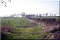
1
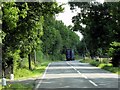
Kirklington Road
north of the village looking North West
Image: © Tom Courtney
Taken: 2 Oct 2005
0.09 miles
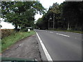
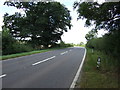
3
Eakring Lane junction with Kirklington Road
Image: © Neil Theasby
Taken: 15 Jan 2016
0.10 miles
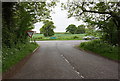
7
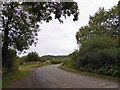
Right angle bend ahead on minor road near Kirklington
Image: © Steve Fareham
Taken: 26 Aug 2014
0.22 miles
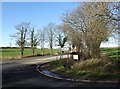
8
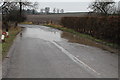
Flooded road near Kirklington
Winter 2012-13 experienced large amounts of rainfall. The ground is saturated, so further rain creates flooding.
Image: © J.Hannan-Briggs
Taken: 10 Feb 2013
0.22 miles