IMAGES TAKEN NEAR TO
Corkhill Lane, NEWARK, NG22 8NW
Introduction
This page details the photographs taken nearby to Corkhill Lane, NG22 8NW by members of the Geograph project.
The Geograph project started in 2005 with the aim of publishing, organising and preserving representative images for every square kilometre of Great Britain, Ireland and the Isle of Man.

There are currently over 7.5m images from over14,400 individuals and you can help contribute to the project by visiting https://www.geograph.org.uk
Image Map
Images are licensed for reuse under creativecommons.org/licenses/by-sa/2.0
Notes
- Clicking on the map will re-center to the selected point.
- The higher the marker number, the further away the image location is from the centre of the postcode.
Image Listing (5 Images Found)
Images are licensed for reuse under creativecommons.org/licenses/by-sa/2.0
Image
Details
Distance
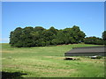
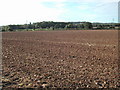
3
Hillside plantation near Kirklington
Image: © Jonathan Thacker
Taken: 16 Jul 2017
0.22 miles
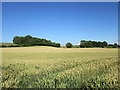
4
Hedgerow and unnamed plantation
Much of the field of wheat has been flattened by heavy rain.
Image: © Jonathan Thacker
Taken: 16 Jul 2017
0.23 miles
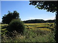
5
Farmland and power lines
Near Kirklington the view is south-west from the road,
Image: © Tom Courtney
Taken: 2 Oct 2005
0.23 miles