IMAGES TAKEN NEAR TO
Brickyard Lane, NEWARK, NG22 8JT
Introduction
This page details the photographs taken nearby to Brickyard Lane, NG22 8JT by members of the Geograph project.
The Geograph project started in 2005 with the aim of publishing, organising and preserving representative images for every square kilometre of Great Britain, Ireland and the Isle of Man.

There are currently over 7.5m images from over14,400 individuals and you can help contribute to the project by visiting https://www.geograph.org.uk
Image Map
Images are licensed for reuse under creativecommons.org/licenses/by-sa/2.0
Notes
- Clicking on the map will re-center to the selected point.
- The higher the marker number, the further away the image location is from the centre of the postcode.
Image Listing (33 Images Found)
Images are licensed for reuse under creativecommons.org/licenses/by-sa/2.0
Image
Details
Distance
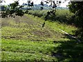
1
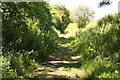
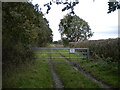
Brickyard Lane
Bridleway from Southwell Trail to Farnsfield
Image: © Richard Croft
Taken: 24 Jul 2012
0.01 miles
3
Five ways footpath junction
On the Southwell Trail near Farnsfield. There are two paths leaving to the right.
Image: © Alan Murray-Rust
Taken: 6 Sep 2020
0.05 miles
4
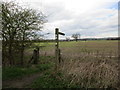
Footpath sign on the Southwell Trail
Two footpaths leave the trail at this point both cutting across cultivated ground.
Image: © Jonathan Thacker
Taken: 9 Apr 2016
0.06 miles
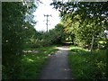
5
Brickyard Lane east of Farnsfield
A farm track parallel to the Southwell Trail, here provided with a gate to prevent unauthorised access to the field beyond. The gate carries a sign instructing members of the public to keep to the public footpath, which is the other side of the hedge on the right.
Image: © Richard Vince
Taken: 24 Oct 2020
0.06 miles
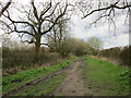
6
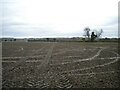
Footpath to Kirklington east of Farnsfield
The tyre tracks heading straight ahead across the field show the approximate course of the footpath.
Image: © Richard Vince
Taken: 24 Oct 2020
0.07 miles
7
Two ways
Footpaths to Hexgreave Park and Kirklington from Southwell Trail
Image: © Richard Croft
Taken: 24 Jul 2012
0.07 miles
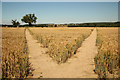
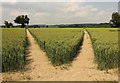
8
Path divergence
Two footpaths in a field of sugar beet near Farnsfield. The paths are more obvious when under a different crop! https://www.geograph.org.uk/photo/4035849
Image: © Alan Murray-Rust
Taken: 6 Sep 2020
0.07 miles
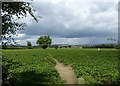
9
Footpath to Edingley
From the height of the old railway embankment carrying the Southwell Trail.
Image: © Alan Murray-Rust
Taken: 6 Sep 2020
0.08 miles
10
Two paths
Footpaths from The Southwell Trail towards Hexgreave Park and Kirklington - a double take from almost two years earlier http://www.geograph.org.uk/photo/3058398
Image: © Richard Croft
Taken: 20 Jun 2014
0.09 miles