IMAGES TAKEN NEAR TO
Manor Fields, NEWARK, NG22 8DU
Introduction
This page details the photographs taken nearby to Manor Fields, NG22 8DU by members of the Geograph project.
The Geograph project started in 2005 with the aim of publishing, organising and preserving representative images for every square kilometre of Great Britain, Ireland and the Isle of Man.

There are currently over 7.5m images from over14,400 individuals and you can help contribute to the project by visiting https://www.geograph.org.uk
Image Map
Images are licensed for reuse under creativecommons.org/licenses/by-sa/2.0
Notes
- Clicking on the map will re-center to the selected point.
- The higher the marker number, the further away the image location is from the centre of the postcode.
Image Listing (27 Images Found)
Images are licensed for reuse under creativecommons.org/licenses/by-sa/2.0
Image
Details
Distance
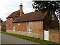
1

Bench mark, garden wall at Walnut Tree Cottage
Hiding behind a hedge and badly worn.
Image: © Alan Murray-Rust
Taken: 6 Sep 2020
0.06 miles
2
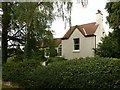
The Manor House, Halam
Late 18th century, with 19th century extension, Listed Grade II.
Image: © Alan Murray-Rust
Taken: 6 Sep 2020
0.07 miles
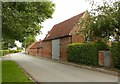
3
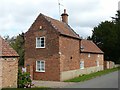
Former dovecote and stable block at Halam Manor
Late 18th century, now converted to residential use, Listed Grade II.
Image: © Alan Murray-Rust
Taken: 6 Sep 2020
0.07 miles
4
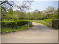
Gateway to Manor Fields, Halam
Off Image, this access road also hosts a public footpath which forms part of the Robin Hood Way.
Image: © Richard Vince
Taken: 7 May 2016
0.07 miles
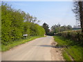
5
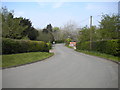
Radley Road, Halam
At the west end of the village, Radley Road performs this S bend, meaning the village must be approached carefully from this end.
Image: © Richard Vince
Taken: 7 May 2016
0.07 miles
6
Former dovecote and stable block at Halam Manor
Late 18th century, now converted to residential use, Listed Grade II.
Image: © Alan Murray-Rust
Taken: 6 Sep 2020
0.07 miles
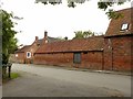
7
Barn at Walnut Tree Cottage
Late 17th century, timber frame encased in brick during the late 18th century, now in residential use, Listed Grade II.
Image: © Alan Murray-Rust
Taken: 6 Sep 2020
0.07 miles
8
The western approach to Halam
Entering Halam village along Radley Road.
Image: © Richard Vince
Taken: 7 May 2016
0.08 miles

10
Outbuilding at Ashdene
Mid 19th century, Listed Grade II, now converted to offices.
Image: © Alan Murray-Rust
Taken: 6 Sep 2020
0.09 miles