IMAGES TAKEN NEAR TO
Dunham Road, NEWARK, NG22 0TA
Introduction
This page details the photographs taken nearby to Dunham Road, NG22 0TA by members of the Geograph project.
The Geograph project started in 2005 with the aim of publishing, organising and preserving representative images for every square kilometre of Great Britain, Ireland and the Isle of Man.

There are currently over 7.5m images from over14,400 individuals and you can help contribute to the project by visiting https://www.geograph.org.uk
Image Map
Images are licensed for reuse under creativecommons.org/licenses/by-sa/2.0
Notes
- Clicking on the map will re-center to the selected point.
- The higher the marker number, the further away the image location is from the centre of the postcode.
Image Listing (17 Images Found)
Images are licensed for reuse under creativecommons.org/licenses/by-sa/2.0
Image
Details
Distance
1
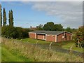
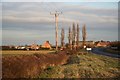
Whimpton Moor pumping station
Despite its proximity to the River Trent, this is actually operated by Anglian Water, not Severn Trent Water. It was originally run by the Lincoln and District Water Board.
Image: © Alan Murray-Rust
Taken: 28 Sep 2017
0.03 miles
2
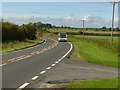
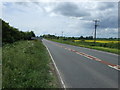
A57 at Whimpton Moor with service 190 bus to Retford
The bus service runs to a timetable but has to be booked by phone.
Four gridsquares meet in the middle of the verge on the right.
Image: © Alan Murray-Rust
Taken: 28 Sep 2017
0.07 miles
4
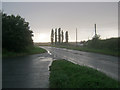
Lay-by at Whimpton
Looking west along a wet A57 following a heavy thunderstorm.
Image: © Trevor Rickard
Taken: 21 Aug 2012
0.08 miles
5
Whimpton Moor
The A57 at Whimpton Moor
Image: © Richard Croft
Taken: 10 Dec 2008
0.12 miles
7
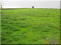
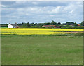
Whimpton Village
Looking south from the back of the A57 lay-by across what appears at first sight to be just another sheep pasture. However, the ridges in the middle of the field are the remains of Whimpton Medieval village.
http://www.nottshistory.org.uk/articles/tts/tts1907/whimpton.htm
Image: © Trevor Rickard
Taken: 21 Aug 2012
0.13 miles
8
Whimpton House
At one time there was a village here but now just a couple of farms represent the former community of Whimpton. An account from 1907 in the Transactions of the Thoroton Society gives a brief description http://www.nottshistory.org.uk/articles/tts/tts1907/whimpton.htm
Image: © Jonathan Thacker
Taken: 20 Dec 2014
0.14 miles
9
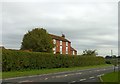
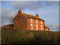
Whimpton House
Formerly known as Ragnall Field Farm, but renamed to reflect the adjacent deserted medieval village of Whimpton. Typical late Georgian (early 19th century) farmhouse in red brick, Listed Grade II.
Image: © Alan Murray-Rust
Taken: 28 Sep 2017
0.14 miles
10

Whimpton House
Tall converted farmhouse on the north side of the A57 Dunham Road. Wet conditions following a summer downpour.
Image: © Trevor Rickard
Taken: 21 Aug 2012
0.14 miles