IMAGES TAKEN NEAR TO
Holme Lane, NEWARK, NG22 0EU
Introduction
This page details the photographs taken nearby to Holme Lane, NG22 0EU by members of the Geograph project.
The Geograph project started in 2005 with the aim of publishing, organising and preserving representative images for every square kilometre of Great Britain, Ireland and the Isle of Man.

There are currently over 7.5m images from over14,400 individuals and you can help contribute to the project by visiting https://www.geograph.org.uk
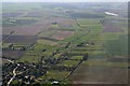
Image Map
Images are licensed for reuse under creativecommons.org/licenses/by-sa/2.0
Notes
- Clicking on the map will re-center to the selected point.
- The higher the marker number, the further away the image location is from the centre of the postcode.
Image Listing (26 Images Found)
Images are licensed for reuse under creativecommons.org/licenses/by-sa/2.0
Image
Details
Distance
3
Ruined building on Laxton Road
Taken to locate the bench mark http://www.geograph.org.uk/photo/4115456 just to the left of the remains of the doorway. Old maps indicate that this was at one time a smithy.
Image: © Alan Murray-Rust
Taken: 8 Aug 2014
0.17 miles
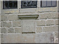
4
Bench mark, Laxton Road
See http://www.geograph.org.uk/photo/4115452 for location.
Image: © Alan Murray-Rust
Taken: 8 Aug 2014
0.17 miles
5
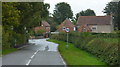
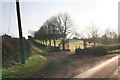
Entering Egmanton from the west
The approach to the village along Kirton Road.
Image: © Andrew Hill
Taken: 1 Oct 2010
0.17 miles
6
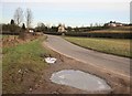
Egmanton around the corner
The road towards Tuxford with ice still at the side. There's a large posh house on the hilltop with, I suspect, a great view over the countryside.
Image: © roger geach
Taken: 1 Feb 2010
0.18 miles
7
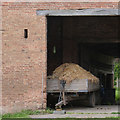
Cartload of muck
In the old barn http://www.geograph.org.uk/photo/4115410 on Kirton Road.
Image: © Alan Murray-Rust
Taken: 8 Aug 2014
0.19 miles
8
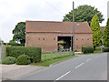
Barn alongside Kirton Road, Egmanton
An unspoilt (from this side) example of an 18th century threshing barn. Listed Grade II.
Image: © Alan Murray-Rust
Taken: 8 Aug 2014
0.19 miles
9
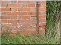
Datestone on the Stone House
According to the Listing description, the name Richard Mapals is inscribed above the date, but this is now too eroded to read.
Image: © Alan Murray-Rust
Taken: 8 Aug 2014
0.19 miles
10
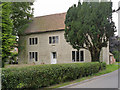
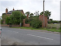
The Stone House, Egmanton
This house stands out amongst the almost ubiquitous use of brick for domestic buildings in the area. Dated 1734 on the stone above the doorway. Listed Grade II.
Image: © Alan Murray-Rust
Taken: 8 Aug 2014
0.19 miles