IMAGES TAKEN NEAR TO
Brail Lane, NEWARK, NG22 0DW
Introduction
This page details the photographs taken nearby to Brail Lane, NG22 0DW by members of the Geograph project.
The Geograph project started in 2005 with the aim of publishing, organising and preserving representative images for every square kilometre of Great Britain, Ireland and the Isle of Man.

There are currently over 7.5m images from over14,400 individuals and you can help contribute to the project by visiting https://www.geograph.org.uk
Image Map
Images are licensed for reuse under creativecommons.org/licenses/by-sa/2.0
Notes
- Clicking on the map will re-center to the selected point.
- The higher the marker number, the further away the image location is from the centre of the postcode.
Image Listing (16 Images Found)
Images are licensed for reuse under creativecommons.org/licenses/by-sa/2.0
Image
Details
Distance
1
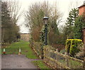
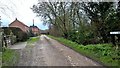
Brail Lane, Eakring, Notts.
The greater part of Brail Lane, off Kirklington Road (a minute's walk behind the photographer), is a farm track in the direction of Eakring Brail Wood. It is however, asphalted up to this point and lined by several houses.
Image: © David Hallam-Jones
Taken: 16 Jan 2015
0.01 miles
2
Brail Lane, Eakring, Notts.
For several miles behind the photographer Brail Lane is nothing more than a farm track. However, as it approaches a C road-type junction with Kirklington Road (a minute's walk ahead) it becomes an asphalted lane lined by several houses. The farm track to the rear leads to Eakring Brail Wood.
Image: © David Hallam-Jones
Taken: 16 Jan 2015
0.02 miles
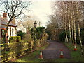
3
Brail Lane, Eakring, Notts.
Brail Lane (ahead) is asphalted for a 50 metres or so, after which it becomes what it perhaps once was - a farm track - running for several miles towards Eakring Brail Wood. The entrance to the National Grid Training & Development Centre is located about 100 metres or so further along Kirklington Road - to the left, whilst the village of Eakring lies a 5 minute walk away behind the photographer.
Image: © David Hallam-Jones
Taken: 16 Jan 2015
0.02 miles
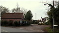
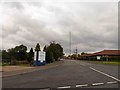
4
Eakring Lane, south of Eakring
The southern approach to Eakring, seen from the entrance to the National Grid Academy site.
Image: © Richard Vince
Taken: 2 Aug 2014
0.05 miles
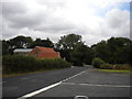
5
Entrance to the National Grid academy Eakring
Image: © Steve Fareham
Taken: 26 Aug 2014
0.07 miles
6
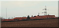
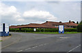
National Grid Training Centre, Eakring, Notts.
The National Grid's Learning and Development Centre, Kirklington Road - on the southern outskirts of Eakring - is seen here from a farm track linking the north-east boundary of Eakring Brail Wood with the Brail Lane/Kirklington Road junction. This £12m training facility opened in November 2012.
Image: © David Hallam-Jones
Taken: 16 Jan 2015
0.07 miles
7
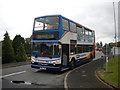
Bus outside National Grid Academy, Eakring
Stagecoach East Midlands' route 28B terminates just south of Eakring village, at the entrance to the National Grid Academy off Eakring Lane. The buses perform a three point turn here to return to Mansfield; this Alexander ALX400 bodied Dennis Trident has just done this in readiness for the journey home.
Image: © Richard Vince
Taken: 2 Aug 2014
0.07 miles
8
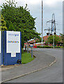
National Grid Academy
The pylon in the background is one of a number erected for training purposes.
Image: © Alan Murray-Rust
Taken: 1 Jun 2014
0.10 miles
9
National Grid Academy
This is the national Grid's national training centre, created on the site of the former BP headquarters for their Midlands oil production.
Image: © Alan Murray-Rust
Taken: 1 Jun 2014
0.12 miles
10
Mill Lane on the sign
But maybe Back Lane on the map at Eakring
Image: © Chris Morgan
Taken: 5 Jan 2016
0.13 miles