IMAGES TAKEN NEAR TO
Chantry Walk, NEWARK, NG22 0DU
Introduction
This page details the photographs taken nearby to Chantry Walk, NG22 0DU by members of the Geograph project.
The Geograph project started in 2005 with the aim of publishing, organising and preserving representative images for every square kilometre of Great Britain, Ireland and the Isle of Man.

There are currently over 7.5m images from over14,400 individuals and you can help contribute to the project by visiting https://www.geograph.org.uk
Image Map
Images are licensed for reuse under creativecommons.org/licenses/by-sa/2.0
Notes
- Clicking on the map will re-center to the selected point.
- The higher the marker number, the further away the image location is from the centre of the postcode.
Image Listing (138 Images Found)
Images are licensed for reuse under creativecommons.org/licenses/by-sa/2.0
Image
Details
Distance
1
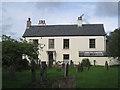
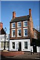
The Chantry, Tuxford
Early nineteenth century house http://www.britishlistedbuildings.co.uk/en-420198-the-chantry-tuxford-nottinghamshire
Image: © Jonathan Thacker
Taken: 28 Sep 2012
0.01 miles
2
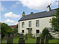
The Chantry, Tuxford
Early 19th century house on the north side of the churchyard, rather plain but with a fine Tuscan style porch. Listed Grade II.
Image: © Alan Murray-Rust
Taken: 15 Aug 2014
0.01 miles
3
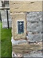
Location of OS Flush Bracket S0644 - Tuxford, St Nicholas' Church
https://www.bench-marks.org.uk/bm11296
Image: © thejackrustles
Taken: 11 Oct 2021
0.01 miles
4
Flush bracket bench market, St Nicholas's Church, Tuxford
See http://www.geograph.org.uk/photo/4126796 for location.
Image: © Alan Murray-Rust
Taken: 15 Aug 2014
0.01 miles
5
OS Flush Bracket S0644 - Tuxford, St Nicholas' Church
https://www.bench-marks.org.uk/bm11296
Image: © thejackrustles
Taken: 11 Oct 2021
0.01 miles
6
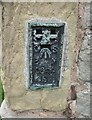
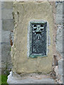
Ordnance Survey Flush Bracket (S0644)
This OS Flush Bracket can be found on the west face of St Nicholas Church. It marks a point 56.799m above mean sea level.
Image: © Adrian Dust
Taken: 26 May 2016
0.02 miles
7
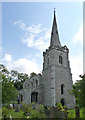
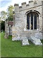
Church of St Nicholas, Tuxford
View from the north west. The lower part of the tower is 13th century. The upper part, including the spire, is 14th century Decorated, as are the aisles, although the windows were recast in the 15th century. The clerestory is also of this date. There is a bench mark http://www.geograph.org.uk/photo/4126788 on the corner of the north aisle. Listed Grade I.
Image: © Alan Murray-Rust
Taken: 15 Aug 2014
0.02 miles
8
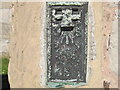
Ordnance Survey Flush Bracket S0644
This bracket can be found on St Nicholas Church.
For more detail see : http://www.bench-marks.org.uk/bm11296
Image: © Peter Wood
Taken: 24 Jul 2012
0.02 miles
9
The Tall House
Appropriately named 19th century house in Tuxford Market Square
Image: © Richard Croft
Taken: 11 Apr 2008
0.02 miles
10
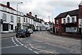
Tuxford High Street
The road to the left leads to Markham Moor or Ollerton, the junction is just around the corner. Turn right towards Lincoln.
Image: © roger geach
Taken: 26 Jun 2009
0.03 miles