IMAGES TAKEN NEAR TO
Kirklington Road, NEWARK, NG22 0DA
Introduction
This page details the photographs taken nearby to Kirklington Road, NG22 0DA by members of the Geograph project.
The Geograph project started in 2005 with the aim of publishing, organising and preserving representative images for every square kilometre of Great Britain, Ireland and the Isle of Man.

There are currently over 7.5m images from over14,400 individuals and you can help contribute to the project by visiting https://www.geograph.org.uk
Image Map
Images are licensed for reuse under creativecommons.org/licenses/by-sa/2.0
Notes
- Clicking on the map will re-center to the selected point.
- The higher the marker number, the further away the image location is from the centre of the postcode.
Image Listing (41 Images Found)
Images are licensed for reuse under creativecommons.org/licenses/by-sa/2.0
Image
Details
Distance
1
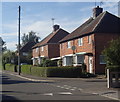
Houses on Triumph Road, Eakring
A village side street.
Image: © Andrew Hill
Taken: 8 Sep 2012
0.02 miles
3
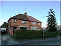
Houses on Triumph Road, Eakring
With a fine monkey puzzle tree to the right.
Image: © Neil Theasby
Taken: 15 Jan 2016
0.07 miles
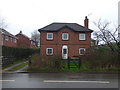
4
Kirklington Road, Eakring
A small village between Southwell and Ollerton, famous for having a residential training centre of National Grid plc, producing oil up to the 1960s and having a vicar called Mompesson, who came from the Plague village of Eyam in Derbyshire.
Image: © Peter Barr
Taken: 8 Oct 2013
0.08 miles
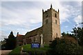
5
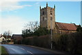
St Andrew's Church, Eakring, Notts.
The Grade II* listed Parish Church on the east side of Kirklington Road is seen here on the approach into the centre of the village. The current building dates back to the C13th, the oldest part being the tower which has a C13th base and a C15th top storey. The building was restored in Elizabethan times, next in the C17th century on the instruction of the Rev. William Mompesson, who widened the nave and added the two porches, and then again in 1881.
Image: © David Hallam-Jones
Taken: 16 Jan 2015
0.10 miles
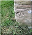
7
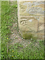
Bench mark, St Andrew's Church, Eakring
See http://www.geograph.org.uk/photo/4024521 for location.
Image: © Alan Murray-Rust
Taken: 1 Jun 2014
0.12 miles
8
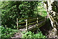
Footbridge on the edge of Eakring.
Close to the Robin hoods way path.
Image: © steven ruffles
Taken: 27 Apr 2019
0.12 miles
9
Ordnance Survey Cut Mark
This OS cut mark can be found on the west face of St Andrew's Church. It marks a point 74.225m above mean sea level.
Image: © Adrian Dust
Taken: 28 May 2016
0.12 miles
10
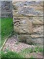
Cut bench mark on Eakring, St Andrew's Church
Cut bench mark at the NW angle of the tower. See http://www.bench-marks.org.uk/bm37679 for details.
Image: © Brian Westlake
Taken: 23 Apr 2011
0.12 miles