IMAGES TAKEN NEAR TO
Colliery Close, NOTTINGHAM, NG2 1PF
Introduction
This page details the photographs taken nearby to Colliery Close, NG2 1PF by members of the Geograph project.
The Geograph project started in 2005 with the aim of publishing, organising and preserving representative images for every square kilometre of Great Britain, Ireland and the Isle of Man.

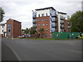
There are currently over 7.5m images from over14,400 individuals and you can help contribute to the project by visiting https://www.geograph.org.uk
Image Map
Images are licensed for reuse under creativecommons.org/licenses/by-sa/2.0
Notes
- Clicking on the map will re-center to the selected point.
- The higher the marker number, the further away the image location is from the centre of the postcode.
Image Listing (408 Images Found)
Images are licensed for reuse under creativecommons.org/licenses/by-sa/2.0
Image
Details
Distance
1
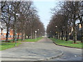
Robin Hood Way
This road was created on a completely new alignment as part of the redevelopment of the Meadows during the 1970s. This section roughly follows the southern end of Wilford Road, one of the main roads south, and part of the old tram network.
Image: © Alan Murray-Rust
Taken: 20 Mar 2009
0.04 miles
2
Robin Hood Way, the Meadows
Looking north, with Ferngill Close on the right.
Image: © Richard Vince
Taken: 10 Jun 2013
0.05 miles
3
Ferngill Close, the Meadows
One of several residential cul de sacs off Robin Hood Way.
Image: © Richard Vince
Taken: 10 Jun 2013
0.05 miles
4
Cremorne Drive
The name commemorates the pub which formerly stood here. The Meadows is now virtually devoid of public houses.
Image: © Alan Murray-Rust
Taken: 7 Apr 2009
0.07 miles
5
Meadowbank House, the Meadows
A block of flats on Robin Hood Way that is rather more modern than the 1970s era housing that predominates in this part of the Meadows.
Image: © Richard Vince
Taken: 10 Jun 2013
0.08 miles
6
Landscaping near Wilford Bridge
There used to be a road link here from Soudan Drive to the vanished roundabout at Riverside Way. Footpaths have been finished and it is now a matter of waiting for the grass to grow.
Image: © Alan Murray-Rust
Taken: 9 Jan 2015
0.08 miles
7
The bottom of Queens Walk
Formerly Queens Drive, and the main way into Nottingham from the south west, even after the closure of Wilford Bridge to traffic. It was some time after that that the current alignment of Queens Drive was created, allowing this attractive avenue to be converted into a pedestrian way. Powered vehicles could again be seen along here in the future as it is earmarked for the propsed Clifton route of the Nottingham tram.
Image: © Alan Murray-Rust
Taken: 20 Mar 2009
0.09 miles
8
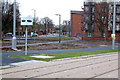
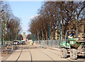
Queen's Walk tram stop
Several of the story poles are lying on the platform ready for installation.
Image: © Alan Murray-Rust
Taken: 23 Jul 2014
0.09 miles
9
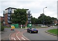
Roundabout near Wilford Toll Bridge
The car is turning into what used to be Wilford Road, once a main road out of the city. When I was young and until 1965 the 40 and 47 trolleybuses from Kildare Road and Ransome Road came down Wilford Road to their terminus here - the roundabout was their turning circle. In due course the NET tramway extension will cut across the roundabout and cross the Toll Bridge on its way to Clifton.
Image: © John Sutton
Taken: 20 Jul 2012
0.09 miles
10
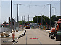
Queens Walk
Looking up the tramway towards the City centre.
Image: © Alan Murray-Rust
Taken: 7 Mar 2014
0.10 miles