IMAGES TAKEN NEAR TO
Wetherlam Close, NOTTINGHAM, NG2 1LG
Introduction
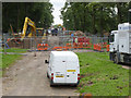
This page details the photographs taken nearby to Wetherlam Close, NG2 1LG by members of the Geograph project.
The Geograph project started in 2005 with the aim of publishing, organising and preserving representative images for every square kilometre of Great Britain, Ireland and the Isle of Man.

There are currently over 7.5m images from over14,400 individuals and you can help contribute to the project by visiting https://www.geograph.org.uk
Image Map
Images are licensed for reuse under creativecommons.org/licenses/by-sa/2.0
Notes
- Clicking on the map will re-center to the selected point.
- The higher the marker number, the further away the image location is from the centre of the postcode.
Image Listing (312 Images Found)
Images are licensed for reuse under creativecommons.org/licenses/by-sa/2.0
Image
Details
Distance
1
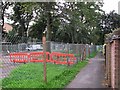
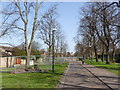
Queen's Walk: narrow path
The majority of the tramway construction site on Queen's Walk is now semi-permanently fenced, posts and chain-link replacing grey welded sectional fence panels along the narrow path at the side.
Image: © John Sutton
Taken: 12 Sep 2012
0.01 miles
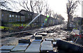
2
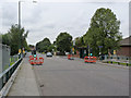
Tramway track laid near Robin Hood Way
Queen's Walk is flat, but the tram track slopes up to cross Robin Hood Way on the level. The track at the crossing has not yet been laid.
Image: © John Sutton
Taken: 26 Sep 2013
0.02 miles
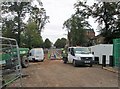
3
Queen's Walk
Work progresses on excavating for the foundations of the track-bed.
Image: © Alan Murray-Rust
Taken: 26 Jul 2013
0.02 miles
4
Queen's Walk
Looking south from Robin Hood Way.
Image: © Alan Murray-Rust
Taken: 13 Jan 2014
0.02 miles
5
Tree stumps. Queens Walk (2)
Removal of some trees has lightened the vista without destroying the feel of the avenue.
Image: © Alan Murray-Rust
Taken: 1 Apr 2012
0.02 miles
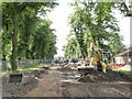
6

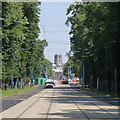
Queens Walk - All it needs is trams
All the works fencing has been removed and this section is essentially ready for trams to start running.
Image: © Alan Murray-Rust
Taken: 9 Jan 2015
0.02 miles
7
Queen's Walk pedestrian crossing
The subway under Robin Hood Way is now closed, and a temporary light-controlled pedestrian crossing has been established in its place.
Image: © Alan Murray-Rust
Taken: 23 Aug 2012
0.02 miles
8
Queen's Walk
The tramway is looking nearly complete over this section.
Image: © Alan Murray-Rust
Taken: 23 Jul 2014
0.02 miles
9
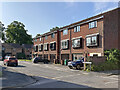
The Meadows: Wetherlam Close
A lot of sub-standard Victorian housing was cleared, and the gridiron road pattern obliterated, in the Meadows redevelopment of the 1970s. After the disastrous 1960s experiment with deck-access flats at Balloon Wood, Basford and Hyson Green - all of which were quickly demolished - the Meadows and St Ann's areas were redeveloped with low-rise housing.
Image: © John Sutton
Taken: 26 Jul 2023
0.02 miles
10
View of the works
Looking south from Robin Hood Way above the now-closed subway. There has been quite a change even in the 4 days since this http://www.geograph.org.uk/photo/3088738 was taken.
Image: © Alan Murray-Rust
Taken: 23 Aug 2012
0.03 miles