IMAGES TAKEN NEAR TO
Castlefields, NOTTINGHAM, NG2 1HN
Introduction
This page details the photographs taken nearby to Castlefields, NG2 1HN by members of the Geograph project.
The Geograph project started in 2005 with the aim of publishing, organising and preserving representative images for every square kilometre of Great Britain, Ireland and the Isle of Man.

There are currently over 7.5m images from over14,400 individuals and you can help contribute to the project by visiting https://www.geograph.org.uk
Image Map
Images are licensed for reuse under creativecommons.org/licenses/by-sa/2.0
Notes
- Clicking on the map will re-center to the selected point.
- The higher the marker number, the further away the image location is from the centre of the postcode.
Image Listing (515 Images Found)
Images are licensed for reuse under creativecommons.org/licenses/by-sa/2.0
Image
Details
Distance
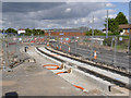
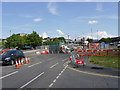
1
Meadows Way at Wilford Road
A short section of the inbound track is still to be installed, pending rearrangement of the junction for road traffic.
Image: © Alan Murray-Rust
Taken: 4 Apr 2014
0.03 miles
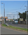
2
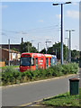
A city-bound tram at Meadows Way
The tram is on Meadows Way. The remaining section of Wilford Road, once a much busier road, which runs parallel, is in the foreground. The rusty green cast-iron object in the foreground is a relic of Nottingham's earlier tram and trolleybus systems - for more about it, see Image
Image: © John Sutton
Taken: 15 Jul 2019
0.03 miles
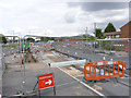
3
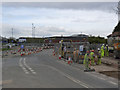
Meadows Way West at Wilford Road
Once the outbound track has been surfaced, it will be possible to divert road traffic and allow the short gap in the inbound to be filled.
Image: © Alan Murray-Rust
Taken: 21 Jul 2014
0.03 miles
4
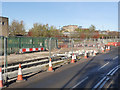
A gap still to be filled
Just a short length of track will need to be added through the area currently required for road access.
Image: © Alan Murray-Rust
Taken: 1 Dec 2013
0.04 miles
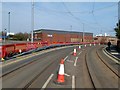
5
The last bit in The Meadows
The gap has finally been filled in meaning that there are now continuous rails on the inbound track from the University to Nottingham Station.
Image: © Alan Murray-Rust
Taken: 31 Aug 2014
0.04 miles
6
Meadows Way at Wilford Road
The gap in the tracks has been waiting to be filled since December http://www.geograph.org.uk/photo/3767470
Image: © Alan Murray-Rust
Taken: 14 Aug 2014
0.04 miles
7
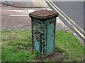
Wilford Road Feeder Pillar
Wilford Road is long gone, and so are the Nottingham City Transport electric trams and later trolleybuses supplied with 550V DC current from this feeder pillar. Power was generated by the Nottingham Corporation Electricity Department at its power stations and high-voltage AC current carried by underground cable to sub-stations where it was converted to DC; that current was then taken through these feeders (there were many around the city) to the overhead trolley wires. (Source of information: "Nottingham Trolleybuses" by David R H Bowler; Trolley Books, 2006.) The new NET tram route to Chilwell will pass this interesting survival on Meadows Way - perhaps it could be preserved as a reminder of earlier forms of electric transport in Nottingham.
Image: © John Sutton
Taken: 20 Jul 2012
0.04 miles
8
Protective barrier on Meadows Way West
The provision of a vehicle guard barrier in a purely urban environment is very unusual, but here there is only a very narrow space between this carriageway and Waterway Street, where traffic is travelling in the opposite direction.
Image: © Alan Murray-Rust
Taken: 20 Mar 2015
0.04 miles
9
A Toton Lane tram on Meadows Way
The road system hereabouts dates from the redevelopment of The Meadows in the 1970s, when Victorian terraced streets were swept away. This part of Meadows Way runs parallel to Waterway Street West.
Image: © John Sutton
Taken: 15 Jul 2019
0.04 miles
10
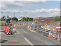
Meadows Way West at Wilford Road
Work on services is still in progress at this location although there is track laid just a few 10s of metres away.
Image: © Alan Murray-Rust
Taken: 26 Jul 2013
0.04 miles