IMAGES TAKEN NEAR TO
Levick Court, NOTTINGHAM, NG2 1HL
Introduction
This page details the photographs taken nearby to Levick Court, NG2 1HL by members of the Geograph project.
The Geograph project started in 2005 with the aim of publishing, organising and preserving representative images for every square kilometre of Great Britain, Ireland and the Isle of Man.

There are currently over 7.5m images from over14,400 individuals and you can help contribute to the project by visiting https://www.geograph.org.uk
Image Map
Images are licensed for reuse under creativecommons.org/licenses/by-sa/2.0
Notes
- Clicking on the map will re-center to the selected point.
- The higher the marker number, the further away the image location is from the centre of the postcode.
Image Listing (353 Images Found)
Images are licensed for reuse under creativecommons.org/licenses/by-sa/2.0
Image
Details
Distance
1
A touch of uncertainty
According to the street name signs, the left hand side is Launder Street, the right hand side is Launders Street. Maps all appear to show it as Launder Street.
Image: © Alan Murray-Rust
Taken: 7 Apr 2009
0.02 miles
2
Our Lady and St Patrick
Catholic church in the Meadows
Image: © Alan Murray-Rust
Taken: 7 Apr 2009
0.03 miles
3
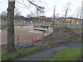
Queens Walk subway
Queens Walk was formerly a main road, but is now a pedestrian way. The road which crosses it here, Robin Hood Way, was a completely new road constructed as part of the redevelopment of the Meadows area in the 1970s. The subway will disappear when the new tram route to Clifton is built along here.
Image: © Alan Murray-Rust
Taken: 7 Apr 2009
0.04 miles
4
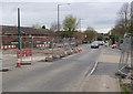
Queen's Walk pedestrian crossing
The subway under Robin Hood Way is now closed, and a temporary light-controlled pedestrian crossing has been established in its place.
Image: © Alan Murray-Rust
Taken: 23 Aug 2012
0.04 miles
5
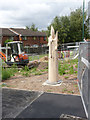
Story pole 7:Faith. Robin Hood Way
A memorial candle, inscribed with the symbols of several world religions.
Image: © Alan Murray-Rust
Taken: 14 Aug 2014
0.05 miles
6
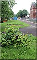
Doing what comes naturally
A feature of lime trees is their ability to produce now shoots at the base of the trunk. This one will nevertheless be doomed for removal like its fellows from the patches beyond.
Image: © Alan Murray-Rust
Taken: 21 Jun 2012
0.05 miles
7
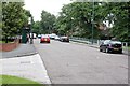
Bridge over Queens Walk
The road level will be lowered here to create a level crossing with the new tram route to Clifton and replacing the existing pedestrian subway http://www.geograph.org.uk/photo/1243395 .
Image: © Alan Murray-Rust
Taken: 21 Jun 2012
0.05 miles
8
Robin Hood Way underpass
The south side of the subway which carries the cycle/walk way along Queen's Walk. It is fenced off and about to be filled in and the tramway will cross Robin Hood Way on the level.
Image: © John Sutton
Taken: 18 Aug 2012
0.05 miles
9
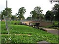
Robin Hood Way pedestrian subway
The subway arch has now been filled in to the level of the foundation base of the tramway. The bridge itself is due to be removed later.
Image: © Alan Murray-Rust
Taken: 30 Jan 2013
0.05 miles
10
Robin Hood Way tramway crossing
The northern carriageway is now complete and the southern carriageway dug up for track construction.
Image: © Alan Murray-Rust
Taken: 4 Apr 2014
0.05 miles