IMAGES TAKEN NEAR TO
Hazel Grove, MANSFIELD, NG21 9RS
Introduction
This page details the photographs taken nearby to Hazel Grove, NG21 9RS by members of the Geograph project.
The Geograph project started in 2005 with the aim of publishing, organising and preserving representative images for every square kilometre of Great Britain, Ireland and the Isle of Man.

There are currently over 7.5m images from over14,400 individuals and you can help contribute to the project by visiting https://www.geograph.org.uk
Image Map
Images are licensed for reuse under creativecommons.org/licenses/by-sa/2.0
Notes
- Clicking on the map will re-center to the selected point.
- The higher the marker number, the further away the image location is from the centre of the postcode.
Image Listing (27 Images Found)
Images are licensed for reuse under creativecommons.org/licenses/by-sa/2.0
Image
Details
Distance
1
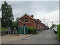
Edwinstowe: the former station building
The station building and yard are now the base for a private ambulance service. The Lancashire, Derbyshire & East Coast Railway (which reached neither Lancashire nor the East Coast) was built in the 1890s, principally to carry coal. However, its Chesterfield to Lincoln line was promoted as The Dukeries Route, and it was hoped that many visitors would come to Edwinstowe to visit Sherwood Forest and the Major Oak. This was the third-largest station on the line (after Chesterfield Market Place and Langwith Junction) and a large station hotel and tea rooms were built nearby, on High Street. Passenger services ceased in 1956 and with the cessation of coal traffic the line from Shirebrook to Tuxford is now used by Network Rail as a test track (see Image] ).
Image]
Image]
Image: © John Sutton
Taken: 10 Jun 2019
0.04 miles
2
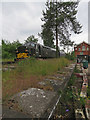
A Class 37 at Edwinstowe
The remaining section of the former Lancashire, Derbyshire & East Coast Railway line, from Shirebrook to Tuxford, is now used as a test track (try https://www.networkrail.co.uk/industry-commercial-partners/research-development-technology/ridc/ridc-tuxford/ ). Colas Railfreight's Class 37/0 37057, built by English Electric in 1962 and painted in the British Railways green livery it carried then, passed through the former Edwinstowe Station at 7.22 on a cloudy June morning. For a clearer view of the former station building on the right, see Image
Image: © John Sutton
Taken: 10 Jun 2019
0.04 miles
4
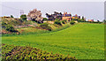
Former station at Edwinstowe, 1995
View NE, towards Lincoln: ex-GCR (formerly Lancashire, Derbyshire & East Coast Railway) Chesterfield - Shirebrook North - Lincoln line, joined at Clipstone Junction (a mile or so west) by the ex-GCR Mansfield Railway, which in turn joined the GCR Sheffield - Nottingham main line at Kirkby-in-Ashfield. Edwinstowe station closed to passengers with services on the Mansfield line from 2/1/56 (goods 4/1/65), although that line remained open for through Excursion trains and for freight. The LD&EC was closed Chesterfield - Shirebrook from 4/12/51, on to Lincoln from 19/9/55 for passengers, but Shirebrook - Clifton-on-Trent remained in use for merry-go-round coal trains until 2003.
Image: © Ben Brooksbank
Taken: 2 May 1995
0.07 miles
5
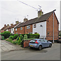
Edwinstowe: cottages on Mill Lane
A typical Nottinghamshire cottage row, at right angles to the road.
Image: © John Sutton
Taken: 10 Jun 2019
0.07 miles
6
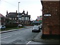
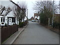
Lidgett
Looking south from the Mill Lane junction. The pub is "Ma Hubbards Eating House and Hotel".
Image: © Mick Garratt
Taken: 4 Dec 2005
0.11 miles
7
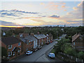
Edwinstowe: Dukeries sunset
A view along Edwinstowe High Street from a window in the Dukeries Lodge Hotel. The parish church spire is on the skyline to the right.
Image: © John Sutton
Taken: 9 Jun 2019
0.12 miles
8
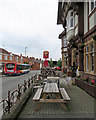
Edwinstowe: High Street and The Dukeries Lodge
When the Lancashire, Derbyshire & East Coast Railway opened its station at Edwinstowe in 1897 considerable Robin-Hood-related tourist traffic was anticipated and the line was marketed as The Dukeries Route. The Dukeries Hotel (now Dukeries Lodge) was built close to the four-platform station, with Railway Tea Rooms opposite. The Dukeries Hotel was partly burned out in 1929, but subsequently rebuilt. For more about it, and some historical photographs, try the Edwinstowe Historical Society website: https://edwinstowehistory.org.uk/local-history/buildings/pubs-and-hostelries/ .
Image] is another view of the hotel.
Image: © John Sutton
Taken: 10 Jun 2019
0.13 miles
9
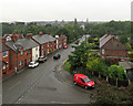
Edwinstowe: the postman's van on a wet morning
The van is parked at the corner of High Street and Boy Lane. For another view from a window in the Dukeries Lodge Hotel, see Image
Image: © John Sutton
Taken: 12 Jun 2019
0.13 miles
10
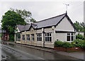
Edwinstowe: former Railway Tea Rooms
When the Lancashire, Derbyshire & East Coast Railway opened its station at Edwinstowe in 1897 considerable Robin-Hood-related tourist traffic was anticipated and the line was marketed as The Dukeries Route. Railway Tea Rooms were built at the start of the station approach, opposite The Dukeries Hotel. Part of the building is now occupied by a Chinese takeaway.
Image: © John Sutton
Taken: 11 Jun 2019
0.13 miles