IMAGES TAKEN NEAR TO
Ollerton Road, MANSFIELD, NG21 9QE
Introduction
This page details the photographs taken nearby to Ollerton Road, NG21 9QE by members of the Geograph project.
The Geograph project started in 2005 with the aim of publishing, organising and preserving representative images for every square kilometre of Great Britain, Ireland and the Isle of Man.

There are currently over 7.5m images from over14,400 individuals and you can help contribute to the project by visiting https://www.geograph.org.uk
Image Map
Images are licensed for reuse under creativecommons.org/licenses/by-sa/2.0
Notes
- Clicking on the map will re-center to the selected point.
- The higher the marker number, the further away the image location is from the centre of the postcode.
Image Listing (86 Images Found)
Images are licensed for reuse under creativecommons.org/licenses/by-sa/2.0
Image
Details
Distance
1
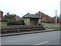
Bus stop and shelter on Ollerton Road, Edwinstowe
Image: © JThomas
Taken: 19 Mar 2015
0.09 miles
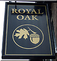
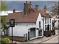
2
The Royal Oak pub, Edwinstowe
On Ollerton Road.
Image: © JThomas
Taken: 19 Mar 2015
0.12 miles
5
Maid Marian restaurant and bar
Church Street Edwinstowe.
Image: © Steve Fareham
Taken: 6 Jan 2009
0.13 miles
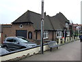
6
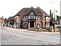
Edwinstowe, Royal Oak
Public house at the corner of Ollerton Road and High Street.
Image: © David Dixon
Taken: 9 Sep 2013
0.14 miles
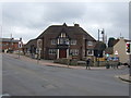
7
The Royal Oak, Edwinstowe
This pub, on the corner of High Street and Ollerton Road has an interesting architectural style obviously designed to take advantage of its prominent location. It was probably built between the wars, a period of expansion for Edwinstowe following the opening of Thoresby Colliery.
Image: © Stephen McKay
Taken: 5 May 2014
0.14 miles
8
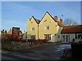
Edwinstowe - The Forest Lodge Hotel
Photo taken from St Mary's churchyard.
Image: © Dave Bevis
Taken: 4 May 2013
0.14 miles
9
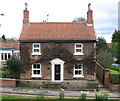
Edwinstowe - Church Street No 6
Photo taken from St Mary's churchyard.
Image: © Dave Bevis
Taken: 4 May 2013
0.14 miles
10
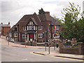
Edwinstowe Crossroads, Notts.
The Royal Oak public house, and opposite, part of the boundary wall of the town's small war memorial garden. Between the two of these High Street - the main shopping street - descends gently downhill. Ollerton Road (the A6075) - the main road between Mansfield Woodhouse and Ollerton (off to the left of the image) - is seen in the forefront of the picture.
Image: © David Hallam-Jones
Taken: 8 Aug 2016
0.14 miles