IMAGES TAKEN NEAR TO
Mansfield Road, MANSFIELD, NG21 9NL
Introduction
This page details the photographs taken nearby to Mansfield Road, NG21 9NL by members of the Geograph project.
The Geograph project started in 2005 with the aim of publishing, organising and preserving representative images for every square kilometre of Great Britain, Ireland and the Isle of Man.

There are currently over 7.5m images from over14,400 individuals and you can help contribute to the project by visiting https://www.geograph.org.uk
Image Map
Images are licensed for reuse under creativecommons.org/licenses/by-sa/2.0
Notes
- Clicking on the map will re-center to the selected point.
- The higher the marker number, the further away the image location is from the centre of the postcode.
Image Listing (92 Images Found)
Images are licensed for reuse under creativecommons.org/licenses/by-sa/2.0
Image
Details
Distance
1
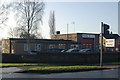
Edwinstowe fire station
Edwinstowe fire station, West Lane, Edwinstowe, Nottinghamshire
Image: © Kevin Hale
Taken: 5 Dec 2009
0.05 miles
2
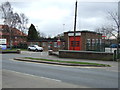
Edwinstowe Fire Station
On Mansfield Road (A6075).
Image: © JThomas
Taken: 17 Mar 2014
0.05 miles

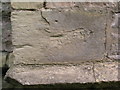
4
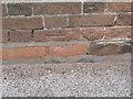
Cut Mark: Edwinstowe Village Hall
Only the datum cut is visible, arrow cuts having been lost to brick replacement. See http://www.geograph.org.uk/photo/3424016 for a wider view and http://www.bench-marks.org.uk/bm48246 for details of the mark.
Image: © Brian Westlake
Taken: 17 Sep 2012
0.08 miles
5
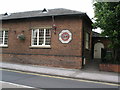
Edwinstowe Village Hall
The east end of the village hall, and former schoolhouse. It carries a cut bench mark low down near the right-hand angle. See http://www.geograph.org.uk/photo/3424006 for a close-up.
Image: © Brian Westlake
Taken: 17 Sep 2012
0.08 miles
6
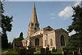
St.Mary's church, Edwinstowe
Local tradition asserts that Robin Hood and Maid Marian were married here - if they were, the grand 12th century tower would have already been built. The church looks Perpendicular from the outside, but there are Norman and Decorated arcades inside. St.Mary's is well kept and usually open - well worth a visit.
Image: © Richard Croft
Taken: 11 Sep 2006
0.09 miles
8
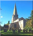
St Mary's Church, Edwinstowe, Notts.
The supposed location of the wedding of Robin Hood and Maid Marian seen here from the southern boundary of the graveyard, access to which is via a footpath and gate from church's car park.
Image: © David Hallam-Jones
Taken: 8 Aug 2016
0.10 miles
9
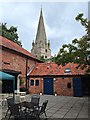
Ollerton Road, Edwinstowe, Notts.
The Courtyard and some of the out-buildings of the former Church Farm on the north side of Ollerton Road, obliquely opposite the town's war memorial, with St Mary's Church forming the backdrop. This former farm now hosts some offices, a cafe and a small commercial art gallery.
Image: © David Hallam-Jones
Taken: 8 Aug 2016
0.10 miles
10
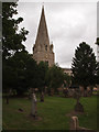
Old Cut Mark on Edwinstowe Church
This mark on a buttress at the SW angle of the tower is not listed on the Ordnance Survey database, but one on the NW angle is (see http://www.geograph.org.uk/photo/3423951 ).
Image: © Brian Westlake
Taken: 17 Sep 2012
0.10 miles