IMAGES TAKEN NEAR TO
St. Edwins Drive, MANSFIELD, NG21 9LX
Introduction
This page details the photographs taken nearby to St. Edwins Drive, NG21 9LX by members of the Geograph project.
The Geograph project started in 2005 with the aim of publishing, organising and preserving representative images for every square kilometre of Great Britain, Ireland and the Isle of Man.

There are currently over 7.5m images from over14,400 individuals and you can help contribute to the project by visiting https://www.geograph.org.uk
Image Map
Images are licensed for reuse under creativecommons.org/licenses/by-sa/2.0
Notes
- Clicking on the map will re-center to the selected point.
- The higher the marker number, the further away the image location is from the centre of the postcode.
Image Listing (82 Images Found)
Images are licensed for reuse under creativecommons.org/licenses/by-sa/2.0
Image
Details
Distance
2
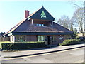
Sherwood Forest Youth Hostel
Situated in Forest Corner, this youth hostel was opened in 1998 and is a short distance from the Sherwood Forest Visitor Centre and Major Oak. Situated on the northern edge of Edwinstowe village, its postcode is NG21 9RN.
Image: © David Hillas
Taken: 8 Mar 2010
0.12 miles

4
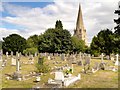
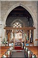
St Mary's Church and Graveyard, Edwinstowe
The Parish Church of St Mary at Edwinstowe, dates from around 1175. It was restored in 1869 and 1890. It is visited by tourists, who come to see the church where, according to some versions of the legend, Robin Hood and Maid Marian (http://www.mainlesson.com/display.php?author=marshall&book=robin&story=marian The Baldwin Project) were married.
St Mary’s Church is a Grade II listed parish church (English Heritage ID:242216 http://www.britishlistedbuildings.co.uk/en-242216-church-of-st-mary-edwinstowe-nottinghams British Listed Buildings).
Image: © David Dixon
Taken: 9 Sep 2013
0.13 miles
5
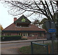
Edwinstowe, Notts
The Youth Hostel Association (YHA) hostel in Forest Corner (a road name) from a public car park opposite.
Image: © David Hallam-Jones
Taken: 29 Oct 2014
0.13 miles
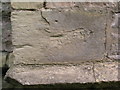
7
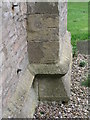
Cut Mark: Edwinstowe Church
Cut mark on a buttress at the NW angle of the church tower. See http://www.bench-marks.org.uk/bm48245 for details of the mark. There is also another mark on the SW buttress - see http://www.geograph.org.uk/photo/3423966 for photo.
Image: © Brian Westlake
Taken: 17 Sep 2012
0.14 miles
8
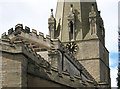
Edwinstowe - church roofline stonework
For a fuller view of St Mary's Parish Church and more information on its history, please see Richard Croft's Image
Image: © Dave Bevis
Taken: 4 May 2013
0.14 miles
9
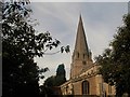
Edwinstowe village
Church spire view from the church yard
Image: © norman griffin
Taken: 10 Oct 2017
0.14 miles
10
Old Cut Mark on Edwinstowe Church
This mark on a buttress at the SW angle of the tower is not listed on the Ordnance Survey database, but one on the NW angle is (see http://www.geograph.org.uk/photo/3423951 ).
Image: © Brian Westlake
Taken: 17 Sep 2012
0.14 miles