IMAGES TAKEN NEAR TO
Mansfield Road, MANSFIELD, NG21 9AB
Introduction
This page details the photographs taken nearby to Mansfield Road, NG21 9AB by members of the Geograph project.
The Geograph project started in 2005 with the aim of publishing, organising and preserving representative images for every square kilometre of Great Britain, Ireland and the Isle of Man.

There are currently over 7.5m images from over14,400 individuals and you can help contribute to the project by visiting https://www.geograph.org.uk
Image Map
Images are licensed for reuse under creativecommons.org/licenses/by-sa/2.0
Notes
- Clicking on the map will re-center to the selected point.
- The higher the marker number, the further away the image location is from the centre of the postcode.
Image Listing (19 Images Found)
Images are licensed for reuse under creativecommons.org/licenses/by-sa/2.0
Image
Details
Distance
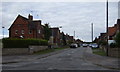
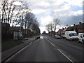
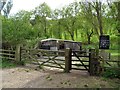
2
Mansfield Road (B6030)
Heading west through Clipstone.
Image: © JThomas
Taken: 7 Sep 2013
0.04 miles
3
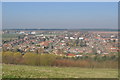
View over New Clipstone
From the colliery spoil heap (now a country park) the new village can be seen to the left. Even though the pit closed in 2003 industrial estates between the village and Mansfield as well as a good rail service at Mansfield have meant housing growth.
Image: © Ashley Dace
Taken: 8 Mar 2011
0.08 miles
4

New Clipstone looking north west
The view from the old colliery waste tip, now a Country Park. Despite the closure of the colliery there has been a considerable amount of new housing development, although this particular area has been established for longer.
Image: © Alan Murray-Rust
Taken: 23 Dec 2007
0.10 miles
5
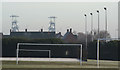
A reminder of the past
The twin headgear of the former Clipstone Colliery are a reminder of the coal industry that created New Clipstone.
Image: © Alan Murray-Rust
Taken: 23 Dec 2007
0.15 miles
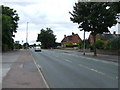
7
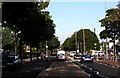
New Clipstone
The main road through New Clipstone, a village built up around the mining industry & now undergoing regeneration after the closure of Clipstone Colliery.
Image: © Lynne Kirton
Taken: 24 Sep 2005
0.20 miles
8
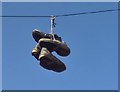
Two pairs of shoes
Why they were hanging high above the road from the telegraph wire was a story we never heard.
Image: © Chris Morgan
Taken: 3 Oct 2017
0.20 miles
9
Vicar Water - Brook running across Smallholding
The brook is lined by a row of willow trees to the left and poplar trees to the right.
Image: © Alan Heardman
Taken: 15 Mar 2008
0.21 miles
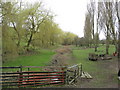
10
The lambing shed at Vicar Water Country Park
The chalkboard indicates that seventy four lambs were recently born at the country park which has grown out of an unpromising coal mining environment.
Image: © Neil Theasby
Taken: 30 Apr 2019
0.21 miles