IMAGES TAKEN NEAR TO
Windmill Way, MANSFIELD, NG21 0QX
Introduction
This page details the photographs taken nearby to Windmill Way, NG21 0QX by members of the Geograph project.
The Geograph project started in 2005 with the aim of publishing, organising and preserving representative images for every square kilometre of Great Britain, Ireland and the Isle of Man.

There are currently over 7.5m images from over14,400 individuals and you can help contribute to the project by visiting https://www.geograph.org.uk
Image Map
Images are licensed for reuse under creativecommons.org/licenses/by-sa/2.0
Notes
- Clicking on the map will re-center to the selected point.
- The higher the marker number, the further away the image location is from the centre of the postcode.
Image Listing (33 Images Found)
Images are licensed for reuse under creativecommons.org/licenses/by-sa/2.0
Image
Details
Distance
1
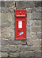
Blidworth Church postbox ref NG21 55
EVIIR wall box with the early cipher.
Image: © Alan Murray-Rust
Taken: 1 Jun 2014
0.03 miles
2
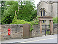
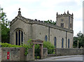
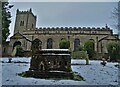
Blidworth Church postbox and churchyard gate
The churchyard gateway dates from the early 19th century (the cast iron gates are mid-19th century). Listed Grade II for group value.
The postbox is shown close-up here http://www.geograph.org.uk/photo/4015729
Image: © Alan Murray-Rust
Taken: 1 Jun 2014
0.04 miles
3
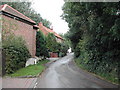
Ricket Lane, Blidworth
viewed NW near to the junction with Main Street, Blidworth
Image: © Tom Courtney
Taken: 25 Sep 2005
0.04 miles
4
Blidworth Church from Ricket Lane
There is a bench mark http://www.geograph.org.uk/photo/4015742 a short distance to the left of the brick building.
Image: © Alan Murray-Rust
Taken: 1 Jun 2014
0.04 miles
5
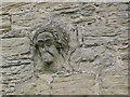
Carved head on Blidworth church
A 14th century carving incorporated into the north wall of the nave http://www.geograph.org.uk/photo/4015748 which was rebuilt in 1739-40.
The accidental juxtaposition of the stone to the right of the head gives the impression of someone swimming, the irregular bedding of the surrounding stones giving a watery texture.
Image: © Alan Murray-Rust
Taken: 1 Jun 2014
0.04 miles
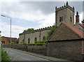
6
Church of St Mary of the Purification, Blidworth
The nave was heavily rebuilt between 1739-40, the 15th century tower being retained (although restored). The east end was rebuilt again in Gothic style in 1839. Listed Grade II*.
Image: © Alan Murray-Rust
Taken: 1 Jun 2014
0.04 miles
7
Inverted bench mark, Blidworth churchyard wall
Inversion of a bench mark can mean that it has been taken off the list, but this one is specifically noted as inverted. Whether it was created like this, or the stone became inverted during reconstruction of the wall and was re-levelled is indeterminable. See http://www.geograph.org.uk/photo/4015744 for location.
Image: © Alan Murray-Rust
Taken: 1 Jun 2014
0.05 miles
8
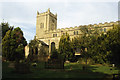
Blidworth - Church of St Mary of the Purification
Image: © Colin Park
Taken: 9 Oct 1998
0.05 miles
9
Church of St Mary of the Purification
In Blidworth. According to legend, Maid Marian of Robin Hood fame lived in a cottage opposite this church. My picture shows a miniature model of the church in stone or concrete - I didn't check.
Image: © Neil Theasby
Taken: 30 Dec 2020
0.05 miles
10
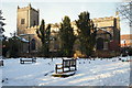
St Mary's Church, Blidworth, Notts.
This is the south side of the Church. Originally a Norman building but with only the west tower remaining of the medieval church (C15th, much restored). The body of the church was re-built in Classical style in 1739-40 with round-headed windows. The church is situated in Main Street on the highest point in the village.
Image: © David Hallam-Jones
Taken: 31 Dec 2014
0.06 miles