IMAGES TAKEN NEAR TO
Ricket Lane, MANSFIELD, NG21 0PF
Introduction
This page details the photographs taken nearby to Ricket Lane, NG21 0PF by members of the Geograph project.
The Geograph project started in 2005 with the aim of publishing, organising and preserving representative images for every square kilometre of Great Britain, Ireland and the Isle of Man.

There are currently over 7.5m images from over14,400 individuals and you can help contribute to the project by visiting https://www.geograph.org.uk
Image Map
Images are licensed for reuse under creativecommons.org/licenses/by-sa/2.0
Notes
- Clicking on the map will re-center to the selected point.
- The higher the marker number, the further away the image location is from the centre of the postcode.
Image Listing (14 Images Found)
Images are licensed for reuse under creativecommons.org/licenses/by-sa/2.0
Image
Details
Distance
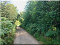
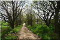
1
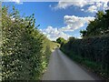
Ricket Lane near Blidworth
Pictured here cutting through the south west corner of the grid square this narrow lane is surrounded for much of its length by tall, dense hedgerow.
Image: © Jonathan Clitheroe
Taken: 8 Oct 2022
0.07 miles
2
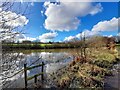
Overflowing pond
At the end of a wet February, this pond was flooding on to the neighbouring footpath.
Image: © Ian Calderwood
Taken: 24 Feb 2024
0.11 miles
3
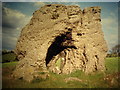
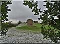
Druid Stone
Glacial rock outcrop
NOTE: this scanned slide has been reproduced back to front; if you intend to reuse it you will need to flip it horizontally.
Image: © Deborah McDonald
Taken: 18 Aug 2003
0.17 miles
4
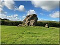
Druid Stone
Natural rock formation consisting of conglomerate material known as puddingstone. The hollowed-out area is due to human activity and may have been an attempt at a Solstice sunrise alignment. The site is well described on the Megalithic Portal website and a cluster of similarly-formed rocks can be found in a wooded area to the north west at SK574568, just off the Robin Hood Way.
Image: © Jonathan Clitheroe
Taken: 8 Oct 2022
0.18 miles
5
A view of The Druid Stone near Bledworth
Sitting in a private field with no public access, this glacial erratic has survived in situ for countless centuries. No doubt once it sat in a clearing in Sherwood Forest, before witnessing deforestation and enclosure. Its saving grace was probably that it was simply too big to move or easily break up.
My photograph was taken from the south. The view from the west or east would have shown that humans of the past created a rough hole through the rock - "According to local folklore, sick children were passed through the hole in the Druid Stone in an attempt to cure childhood illnesses such as whooping cough or rickets, with speculation that the act of passing through the stone symbolised the rebirth of a healthy child" - says Atlas Obscura.
Image: © Neil Theasby
Taken: 30 Dec 2020
0.18 miles
6
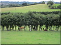
Grass field with alpacas
My dog was utterly transfixed by these. He just stared and stared.
Image: © Jonathan Thacker
Taken: 21 Jul 2019
0.19 miles
7
West of Blidworth
View south from New Lane
Image: © Neil Theasby
Taken: 30 Dec 2020
0.22 miles
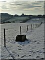
9
Cycle Route 6 and the Robin Hood Way on New Lane
The Lane is a byway running to the west side of Blidworth
Image: © Tim Heaton
Taken: 19 May 2013
0.24 miles
10
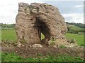
Druid stone
A pillar of cemented glacial gravels on a base of Nottingham Castle Formation (Bunter Pebble Beds)
Image: © Jim Thornton
Taken: 2 Oct 2006
0.24 miles